
Chapter VIIIPatriarchal AgeאבותAbraham
בית אל והעי
Between Bethel and Ai
Calling on the Name
1738 BCEHebrew year 2023traditionalב׳כ״ג
וַיַּעְתֵּק מִשָּׁם הָהָרָה מִקֶּדֶם לְבֵית־אֵל וַיֵּט אָהֳלֹה בֵּית־אֵל מִיָּם וְהָעַי מִקֶּדֶם
“And he removed from thence unto the mountain on the east of Beth-el, and pitched his tent, having Beth-el on the west, and Ai on the east.”
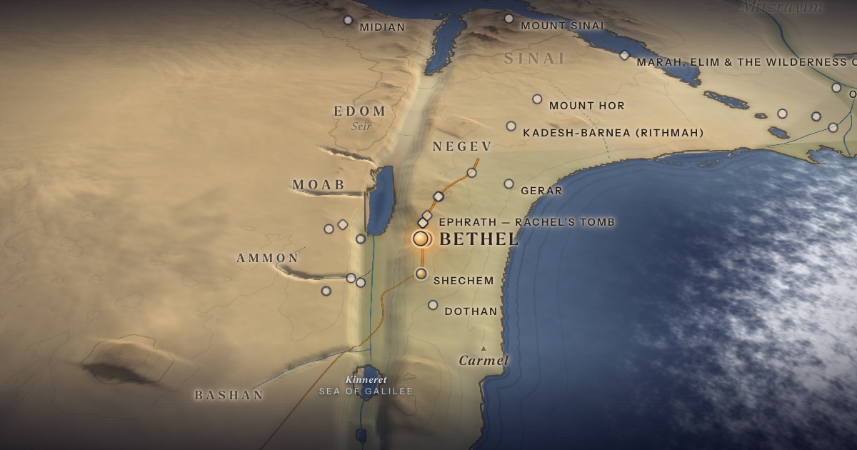
Moving south along the watershed ridge, Abram camps on a height between Bethel and Ai and builds a second altar. Then he continues “going on still toward the South” — into the Negev.
Location
Bethel is usually identified with Beitin, and Ai with et-Tell, about 3 km apart, north of Jerusalem.
- Bethelבֵּית־אֵל — Beitin (most common identification)Probable identification 31.93° N, 35.24° EAn altar between Bethel and Ai; later, Jacob’s dream.
- Aiהָעַי — et-Tell (common identification)Probable identification 31.92° N, 35.26° E“Bethel on the west, and Ai on the east.”
The journey
Shechem → Bethel≈ 35 km
Along the watershed ridge. Roughly 2–3 days at the pace of flocks.
Bethel → the Negev≈ 120 km
South along the ridge road. Roughly 6–10 days at the pace of flocks.
Distances are estimates along plausible ancient corridors, not measured routes.
Chronology
The year Abram enters Canaan (Gen. 12:4–8).
Biblical Narrative
Abram moves from Shechem to the hill east of Bethel, with Bethel to the west and Ai to the east, and “called upon the name of the LORD” (12:8). Then he journeys on by stages toward the Negev (12:9). After Egypt he will return to this very spot, “unto the place of the altar” (13:3–4).
Geography
The patriarchs travel the ridge road — sometimes called the “Way of the Patriarchs” — that follows the watershed of the hill country from Shechem through Bethel, Jerusalem and Hebron to Beersheba. The ridge avoids the deep valleys that cut east and west, and it links the places where Abraham, Isaac and Jacob build altars.
Historical Context
In the Middle Bronze Age the hill country was thinly settled compared with the coastal plain and valleys: a few fortified towns — Shechem, Bethel, Jerusalem, Hebron — with open land between them for pastoralists.
Archaeology
Beitin was excavated by W. F. Albright and J. L. Kelso (1934–1960); Israel Finkelstein and Lily Singer-Avitz have since re-dated much of the material. Et-Tell was a large city in the Early Bronze Age and then lay abandoned for more than a thousand years — a famous problem for the later story of Ai’s conquest in Joshua 7–8.
Jewish Tradition
This ridge becomes, in Genesis 28, the scene of Jacob’s dream; Jewish tradition treats Bethel as one of the great sites of revelation.
Traditional and rabbinic interpretation — presented as tradition, not as archaeological evidence.
Identification
- What the text says
- “Beth-el on the west, and Ai on the east” (12:8) — a precise relative description.
- Traditional identification
- The Arabic village name Beitin is widely thought to preserve “Bethel.”
- Scholarly proposals
- Beitin = Bethel is the majority view. Et-Tell = Ai is common but debated; Khirbet el-Maqatir and other sites have been proposed.
- What remains uncertain
- The exact spot of Abram’s altar is unknown.
Sources
Hebrew Bible
- Genesis 12:8–9בראשית י״ב:ח׳–ט׳
- Genesis 13:3–4בראשית י״ג:ג׳–ד׳
Verse numbers follow the Hebrew (Masoretic) text. Links open the text in Hebrew and English on Sefaria.
Modern scholarship
- James L. Kelso, The Excavation of Bethel (1934–1960), AASOR 39 (Cambridge, MA: American Schools of Oriental Research, 1968).
- Israel Finkelstein and Lily Singer-Avitz, “Reevaluating Bethel,” Zeitschrift des Deutschen Palästina-Vereins 125 (2009): 33–48.
- Nahum M. Sarna, The JPS Torah Commentary: Genesis (Philadelphia: Jewish Publication Society, 1989).
Atlases & reference works
- Ephraim Stern (ed.), The New Encyclopedia of Archaeological Excavations in the Holy Land, 4 vols. (Jerusalem: Israel Exploration Society & Carta, 1993); vol. 5 (2008). — s.v. “Bethel”; “Ai”
- Anson F. Rainey and R. Steven Notley, The Sacred Bridge: Carta’s Atlas of the Biblical World (Jerusalem: Carta, 2006).
Translation
- The Holy Scriptures According to the Masoretic Text (Philadelphia: Jewish Publication Society of America, 1917). Source of the short quotations on each card (public domain). Verse numbers follow the Hebrew text.