
Chapter XLIExodus & WildernessמדברWilderness
הר ההר
Around Edom
Mount Hor and the serpent of brass
Av · 1274 BCEHebrew year 2487traditionalאב ב׳תפ״ז
דֶּרֶךְ הַמֶּלֶךְ נֵלֵךְ לֹא נִטֶּה יָמִין וּשְׂמֹאול עַד אֲשֶׁר־נַעֲבֹר גְּבוּלֶךָ׃
“we will go along the king’s highway, we will not turn aside to the right hand nor to the left, until we have passed thy border.”
From Kadesh, Moses asks the king of Edom for passage along the King’s Highway. Edom refuses and comes out armed; Israel turns away. At Mount Hor, on Edom’s border, Aaron dies and is mourned thirty days. The Canaanite king of Arad attacks and takes captives. Going around Edom, the people complain; fiery serpents bite them, and Moses makes a serpent of brass. The camps of Zalmonah, Punon and Oboth bring Israel to Iye-abarim, on the border of Moab.
Location
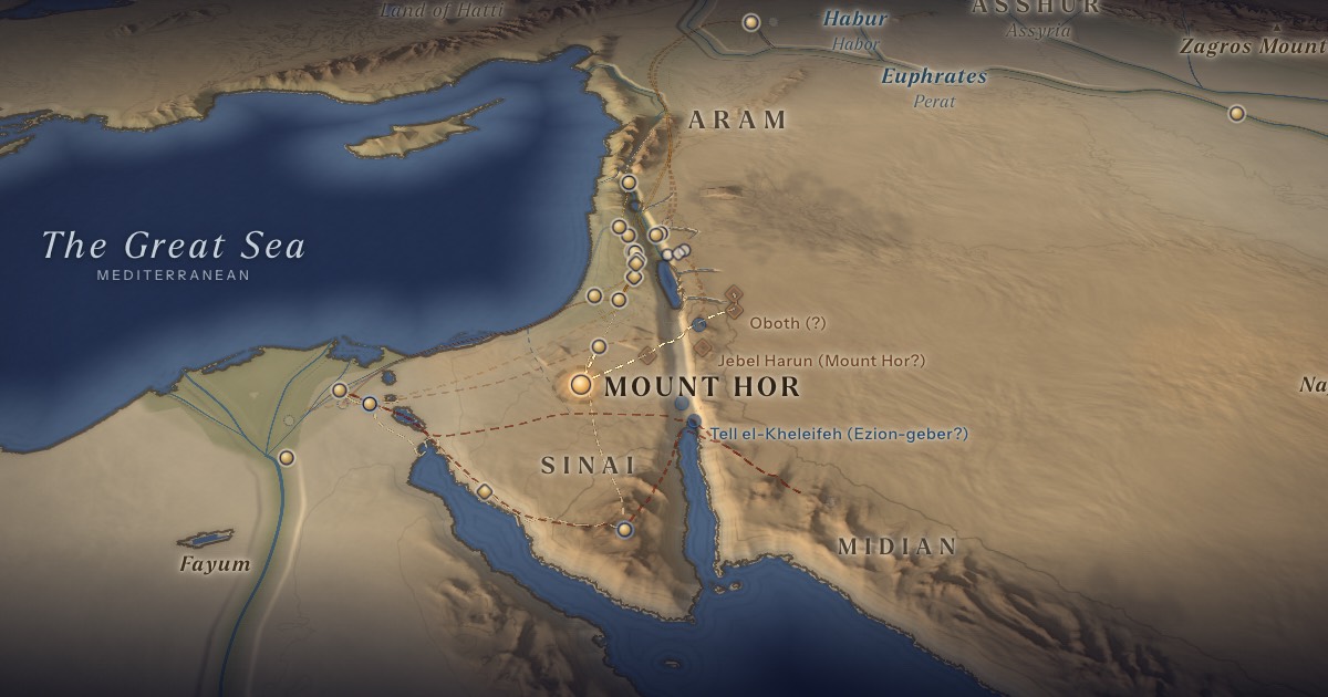
Drawn as on the ArtScroll Chumash map: Mount Hor south-west of Kadesh, west of the Arabah, then east by Zalmonah and Punon to Oboth and Iye-abarim, in the desert east of Edom and Moab. Mount Hor is unidentified; Josephus placed it near Petra, at Jebel Harun. Punon is probably the copper district of Feinan. The other stations are unlocated.
- Mount Horהֹר הָהָר — Unidentified; drawn south-west of Kadesh, west of the Arabah, as on traditional Jewish mapsDisputed 30.22° N, 34.10° EAaron dies on the summit, on the border of Edom.
Proposed locations
- Zalmonah (?)Tradition · ArtScroll Chumash mapStation 35 (Num. 33:41), drawn east of Mount Hor. Position approximate; unlocated.
- Feinan (Punon)Scholarly proposalCopper district; probable Punon, station 36 (Num. 33:42).
- Oboth (?)Tradition · ArtScroll Chumash mapStation 37 (Num. 21:10; 33:43), drawn south-east of the Salt Sea, east of Edom. Position approximate; unlocated.
- Iye-abarim (?)Tradition · ArtScroll Chumash mapStation 38 (Num. 21:11; 33:44), “in the border of Moab,” toward the sunrise. Position approximate; unlocated.
- Jebel Harun (Mount Hor?)Tradition · Josephus; later Christian traditionA peak near Petra crowned by a shrine of Aaron — the other traditional Mount Hor, east of the Arabah.
- TimnaScholarly proposalEgyptian copper mines and a Midianite tent-shrine with a copper serpent.
- Tell el-Kheleifeh (Ezion-geber?)Scholarly proposalNelson Glueck’s Ezion-geber; the identification is now doubted.
The journey
Kadesh → Mount Hor≈ 60 km
To Mount Hor south-west of Kadesh, west of the Arabah, as on the ArtScroll map. Roughly 3–6 days at the pace of a people on the move. Route conjectural.
Mount Hor → Zalmonah → Punon → Oboth → Iye-abarim≈ 250 km
East across the Arabah to the desert east of Edom and Moab (Num. 33:41–44), as on the ArtScroll map. Roughly 13–23 days at the pace of a people on the move. Route conjectural.
Distances are estimates along plausible ancient corridors, not measured routes.
Chronology
The fortieth year (1274 BCE), as charted in the ArtScroll Chumash: after more than three months at Kadesh, Israel moves to Mount Hor. Aaron dies there on 1 Av (Num. 33:38), and the clouds of glory depart. The king of Arad attacks and takes a captive; Israel falls back eight stations to Moseroth until the clouds return. Aaron is mourned through Av, thirty days (Num. 20:29).
Parsha
- Chukasחקת · Numbers 19:1
Biblical Narrative
“Thus saith thy brother Israel” (20:14) — the request appeals to kinship with Esau. Edom refuses (20:18–21). Moses strips Aaron of his garments and puts them on Eleazar; Aaron dies on the mountaintop (20:23–29). The Canaanite king of Arad fights Israel and takes some captive; Israel vows to destroy his cities and names the place Hormah (21:1–3). The people journey “by the way to Yam Suf, to compass the land of Edom” (21:4). The serpent of brass is set on a pole; whoever looks upon it lives (21:6–9). Then Israel camps at Oboth and at Iye-abarim, “in the wilderness which is in front of Moab, toward the sunrising” (21:10–11).
Geography
Kadesh is “a city in the uttermost of thy border,” Moses tells Edom (20:16), and Mount Hor lies “in the edge of the land of Edom” (33:37). Traditional Jewish maps such as ArtScroll’s therefore draw Edom’s land reaching west of the Arabah, into the highlands south of Judah, and set Mount Hor there; Judah’s southern border also runs along Edom (Num. 34:3; Josh. 15:1). From Hor the route crosses the Arabah by Punon, at the foot of the Edomite escarpment, and climbs to the desert east of Edom and Moab. Deuteronomy 2:8 mentions passing “from Elath and from Ezion-geber,” which many maps draw as a detour down the Arabah to the Gulf of Aqaba; Ezion-geber is also listed among the stations of the wandering years (Num. 33:35–36).
Historical Context
The King’s Highway was Transjordan’s main north–south road, from Damascus to the Gulf of Aqaba, later rebuilt by the Romans as the Via Nova Traiana. Whether a kingdom of Edom existed in the Late Bronze Age is debated: Egyptian texts mention the Shasu of Edom, but major settlement on the plateau appears later.
Archaeology
Feinan, at the foot of the Edomite escarpment, was one of the great copper districts of the ancient Near East; excavations by Thomas Levy, Mohammad Najjar and Erez Ben-Yosef show intensive smelting in the 11th–9th centuries BCE. At Timna, Rothenberg’s copper snake from the Midianite tent-shrine is often compared with the serpent of brass.
Jewish Tradition
The Talmud (Rosh Hashanah 2b–3a) and Rashi (on Num. 21:1) teach that when Aaron died the clouds of glory departed, and the “Canaanite” of Arad — Amalek in disguise, says Rashi — took the chance to attack. Rashi (on Deut. 10:6) adds that Israel fell back eight stations, as far as Moseroth, where they mourned Aaron, and then turned forward again; this is why Deuteronomy says Aaron died at Moserah. Josephus (Antiquities 4.82–83) places Aaron’s death near Petra, the basis of the Jebel Harun tradition. The brass serpent survived until King Hezekiah destroyed it because people burned incense to it (2 Kgs 18:4); the Mishnah asks: “Could a serpent kill, or give life?” — rather, when Israel looked upward, they were healed (Rosh Hashanah 3:8).
Traditional and rabbinic interpretation — presented as tradition, not as archaeological evidence.
Identification
- What the text says
- Mount Hor “in the edge of the land of Edom” (Num. 33:37; compare 20:23); Zalmonah, Punon, Oboth and Iye-abarim “in the border of Moab” (33:41–44).
- Traditional identification
- The ArtScroll Chumash map: Mount Hor (station 34) south-west of Kadesh and west of the Arabah, with Zalmonah, Punon and Oboth (35–37) running east and Iye-abarim, “the ruins of the passes” (38), on the border of Moab; most are marked as uncertain. Josephus: Jebel Harun near Petra, where a later shrine of Aaron crowns the summit.
- Scholarly proposals
- Many scholars also look for Hor near Kadesh, since it lies on Edom’s border as seen from Kadesh; a peak such as Jebel Madurah has been suggested. Punon = Feinan (probable). Oboth and Iye-abarim are sought on the desert edge east of Edom and Moab.
- What remains uncertain
- The location of Mount Hor, the stations after it, and the exact route around Edom are uncertain.
Sources
Hebrew Bible
- Numbers 20:14–21:11במדבר כ׳:י״ד–כ״א:י״א
- Numbers 33:37–44במדבר ל״ג:ל״ז–מ״ד
- Deuteronomy 2:1–8דברים ב׳:א׳–ח׳
- Deuteronomy 10:6–7דברים י׳:ו׳–ז׳
Verse numbers follow the Hebrew (Masoretic) text. Links open the text in Hebrew and English on Sefaria.
Jewish tradition & interpretation
Interpretive tradition — not archaeological evidence.
- Rashi (R. Shlomo Yitzḥaki, 1040–1105), Commentary on the Torah. — on Num. 21:1; Deut. 10:6רש״י על במדבר כ״א:א׳; דברים י׳:ו׳
- Babylonian Talmud (Talmud Bavli), redacted c. 6th century CE. — Rosh Hashanah 2b–3aבבלי ראש השנה ב׳ ב–ג׳ א
- Mishnah, redacted by R. Judah ha-Nasi (c. 200 CE). — Rosh Hashanah 3:8משנה ראש השנה ג׳:ח׳
Ancient & late-antique witnesses
- Flavius Josephus, Jewish Antiquities (c. 93–94 CE), Loeb Classical Library (Harvard University Press). — 4.82–83
Modern scholarship
- Thomas E. Levy, Mohammad Najjar and Erez Ben-Yosef (eds.), New Insights into the Iron Age Archaeology of Edom, Southern Jordan (Los Angeles: Cotsen Institute of Archaeology Press, 2014).
- Beno Rothenberg, Timna: Valley of the Biblical Copper Mines (London: Thames & Hudson, 1972).
- Jacob Milgrom, The JPS Torah Commentary: Numbers (Philadelphia: Jewish Publication Society, 1990).
- Graham I. Davies, The Way of the Wilderness: A Geographical Study of the Wilderness Itineraries in the Old Testament (Cambridge: Cambridge University Press, 1979).
Atlases & reference works
- The ArtScroll Chumash, Appendix A: “Charts, Illustrations, and Maps” (Brooklyn: Mesorah Publications, 2015), pp. 1350–1354. — pp. 1351, 1353 The traditional Jewish basis for the wilderness route drawn here: the order of the stations of Numbers 33, Kadesh as Rithmah, Mount Hor west of the Arabah, and the way east of Moab. Also the source of the chronology of the fortieth year, Sihon’s strip north of the Arnon, and the tribes on Gerizim and Ebal. It marks most stations as uncertain, and its maps are schematic.
- Burton MacDonald, “East of the Jordan”: Territories and Sites of the Hebrew Scriptures (Boston: American Schools of Oriental Research, 2000).
Translation
- The Holy Scriptures According to the Masoretic Text (Philadelphia: Jewish Publication Society of America, 1917). Source of the short quotations on each card (public domain). Verse numbers follow the Hebrew text.