
Chapter XIIIPatriarchal AgeאבותAbraham
סדום ועמרה
The Cities of the Plain
Sodom and Gomorrah
Nisan · 1714 BCEHebrew year 2047traditionalניסן ב׳מ״ז
וַיַּשְׁקֵף עַל־פְּנֵי סְדֹם וַעֲמֹרָה וְעַל־כָּל־פְּנֵי אֶרֶץ הַכִּכָּר וַיַּרְא וְהִנֵּה עָלָה קִיטֹר הָאָרֶץ כְּקִיטֹר הַכִּבְשָׁן׃
“and he looked out toward Sodom and Gomorrah, and toward all the land of the Plain, and beheld, and, lo, the smoke of the land went up as the smoke of a furnace.”
Abraham bargains with God for Sodom — for fifty righteous, then ten. Angels lead Lot’s family out; Lot’s wife looks back; fire and brimstone overthrow the cities. At dawn, from the heights near Hebron, Abraham sees smoke rising from the plain “as the smoke of a furnace.”
Location
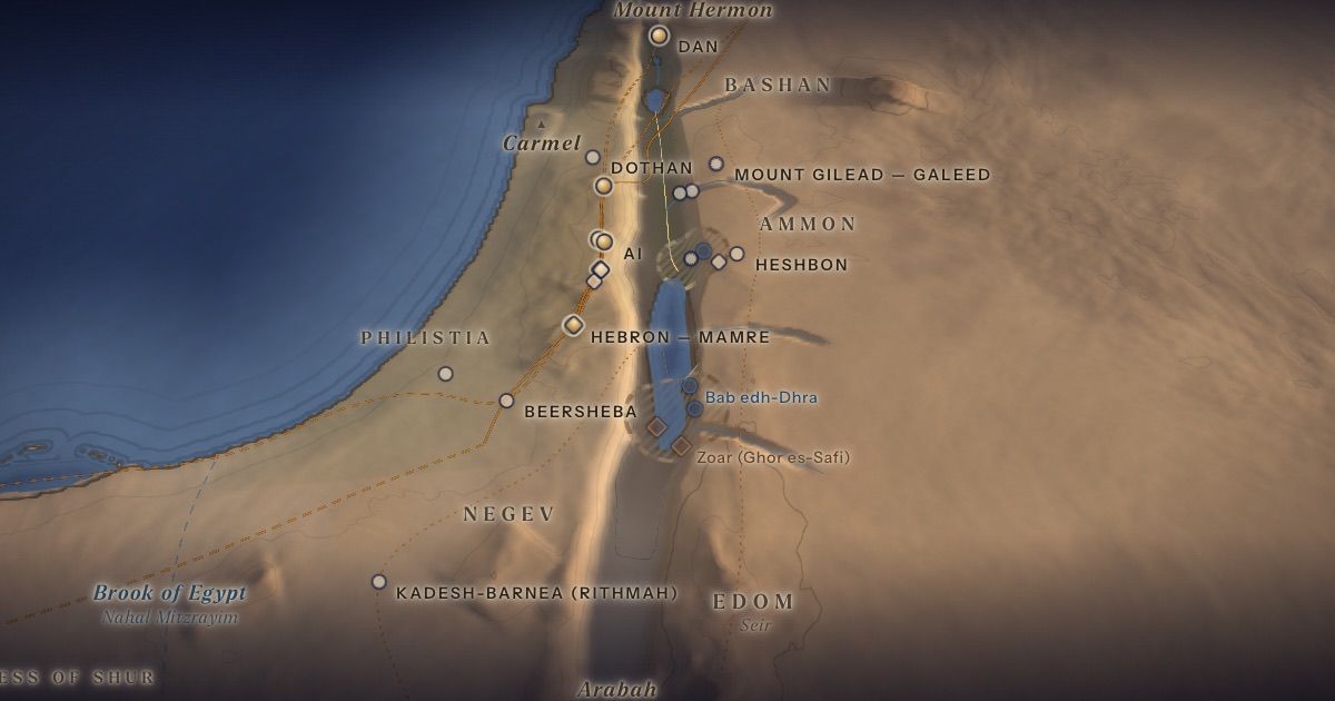
Disputed. The text ties the cities to the Jordan “plain” and to the Vale of Siddim, “the same is the Salt Sea” (14:3). Proposals divide between the north-east and the south-east of the Dead Sea.
- Sodom & Gomorrahסְדֹם וַעֲמֹרָה — Dead Sea basin — exact sites unknownDisputedThe cities of the Jordan plain, overthrown.
Proposed locations
- Tall el-HammamScholarly proposal · S. CollinsLarge Middle Bronze Age city north-east of the Dead Sea. The “airburst” paper about it was retracted in 2025.
- Bab edh-DhraScholarly proposal · Proposed by several writers since the 1970sEarly Bronze Age walled town with an immense cemetery.
- NumeiraScholarly proposalEarly Bronze Age town destroyed by fire; paired by some with Gomorrah.
- Jebel Usdum (Mount Sodom)TraditionA ridge of rock salt; the name preserves the tradition.
- Zoar (Ghor es-Safi)TraditionByzantine Zoara, shown on the Madaba Map; nearby Deir ‘Ain ‘Abata commemorated Lot.
Chronology
Abraham is ninety-nine (Gen. 17:24); by Rashi (on 19:3) the angels come to Lot at Passover.
Biblical Narrative
Three visitors leave Mamre toward Sodom; Abraham pleads: “Shall not the Judge of all the earth do justly?” (18:25). In Sodom, Lot shelters two angels from a violent crowd (19:1–11). At dawn they hurry his family out; fleeing to Zoar, Lot’s wife looks back and becomes a pillar of salt (19:15–26). Abraham rises early and sees the smoke (19:27–28).
Geography
The Dead Sea lies in the deepest part of the Great Rift, its surface today about 430 m below sea level — the lowest land on earth. The basin is framed by salt formations (Mount Sodom is largely rock salt), bitumen seeps (the “slime pits” of 14:10) and sulphur deposits. From the ridge east of Hebron, the view drops some 1,300 m to the sea.
Historical Context
The Early Bronze Age towns of Bab edh-Dhra and Numeira, on the south-eastern plain of the Dead Sea, were destroyed or abandoned in the late 3rd millennium BCE. The Middle Bronze Age city at Tall el-Hammam, north-east of the Dead Sea, was also destroyed and abandoned. Each has been proposed as Sodom.
Archaeology
A 2021 paper claiming that a cosmic airburst destroyed Tall el-Hammam — widely publicised as “evidence for Sodom” — was retracted by the journal Scientific Reports in April 2025 after criticism of its data and methods. No inscription names any of the cities of the plain.
Jewish Tradition
Byzantine tradition, reflected on the Madaba Map, placed Zoar at the south-east end of the Dead Sea (Ghor es-Safi), where a monastery at Deir ‘Ain ‘Abata commemorated Lot’s cave. Jebel Usdum preserves the name “Sodom” at the south-west corner. Rabbinic literature remembers Sodom above all for its cruelty to strangers (Mishnah Avot 5:10; Sanhedrin 109a–b).
Traditional and rabbinic interpretation — presented as tradition, not as archaeological evidence.
Identification
- What the text says
- The cities lie in the “plain (kikkar) of the Jordan” (13:10–12), and the battle is in the Vale of Siddim, “the same is the Salt Sea” (14:3). Zoar is near enough for Lot to reach it by sunrise (19:22–23).
- Traditional identification
- Southern Dead Sea (Byzantine and later tradition): Zoar at Ghor es-Safi; Sodom near Jebel Usdum.
- Scholarly proposals
- Southern proposal: Bab edh-Dhra and Numeira (Early Bronze Age). Northern proposal: Tall el-Hammam (argued by Steven Collins), on the view that the kikkar is the plain north of the Dead Sea.
- What remains uncertain
- No site has been identified with confidence. Many scholars regard the story as an explanatory tradition about the Dead Sea’s desolate landscape.
Sources
Hebrew Bible
- Genesis 18:16–19:38בראשית י״ח:ט״ז–י״ט:ל״ח
- Genesis 13:10–12בראשית י״ג:י׳–י״ב
- Genesis 14:2–3בראשית י״ד:ב׳–ג׳
Verse numbers follow the Hebrew (Masoretic) text. Links open the text in Hebrew and English on Sefaria.
Jewish tradition & interpretation
Interpretive tradition — not archaeological evidence.
- Mishnah, tractate Avot (redacted c. 200 CE). — 5:10משנה אבות ה׳:י׳
- Babylonian Talmud (Talmud Bavli), redacted c. 6th century CE. — Sanhedrin 109a–bבבלי סנהדרין ק״ט א–ב
Ancient & late-antique witnesses
- The Madaba Mosaic Map (6th century CE), Church of St George, Madaba, Jordan; see Michele Piccirillo and Eugenio Alliata (eds.), The Madaba Map Centenary 1897–1997 (Jerusalem: Studium Biblicum Franciscanum, 1999).
Modern scholarship
- Steven Collins and Latayne C. Scott, Discovering the City of Sodom (New York: Howard Books, 2013) — argues for Tall el-Hammam.
- T. E. Bunch et al., “A Tunguska sized airburst destroyed Tall el-Hammam…,” Scientific Reports 11 (2021): 18632 — RETRACTED by the journal in April 2025. Cited only to document that this widely publicised claim was retracted.
- R. Thomas Schaub and Walter E. Rast, Bâb edh-Dhrâʿ: Excavations in the Cemetery Directed by Paul W. Lapp (1965–67) (Winona Lake: Eisenbrauns / ASOR, 1989).
- Konstantinos D. Politis, Sanctuary of Lot at Deir ʿAin ʿAbata in Jordan: Excavations 1988–2003 (Amman: Jordan Distribution Agency, 2012).
- Nahum M. Sarna, The JPS Torah Commentary: Genesis (Philadelphia: Jewish Publication Society, 1989).
Atlases & reference works
- Ephraim Stern (ed.), The New Encyclopedia of Archaeological Excavations in the Holy Land, 4 vols. (Jerusalem: Israel Exploration Society & Carta, 1993); vol. 5 (2008). — s.v. “Bab edh-Dhra”
Translation
- The Holy Scriptures According to the Masoretic Text (Philadelphia: Jewish Publication Society of America, 1917). Source of the short quotations on each card (public domain). Verse numbers follow the Hebrew text.