
Chapter VIIPatriarchal AgeאבותAbraham
שכם
Shechem
The first altar in Canaan
1738 BCEHebrew year 2023traditionalב׳כ״ג
וַיַּעֲבֹר אַבְרָם בָּאָרֶץ עַד מְקוֹם שְׁכֶם עַד אֵלוֹן מוֹרֶה וְהַכְּנַעֲנִי אָז בָּאָרֶץ׃
“And Abram passed through the land unto the place of Shechem, unto the terebinth of Moreh. And the Canaanite was then in the land.”
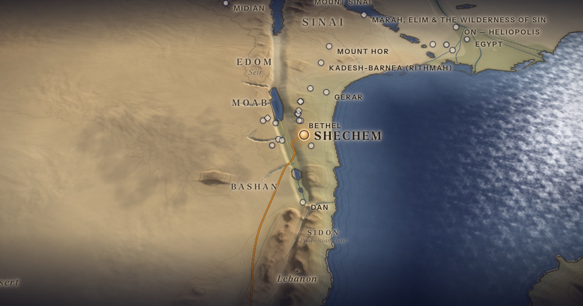
Abram’s first stop in Canaan is Shechem, in the pass between Mount Ebal and Mount Gerizim at the heart of the central hill country. Here God first promises the land to his descendants, and Abram builds an altar.
Location
Tell Balata, on the eastern edge of modern Nablus — a probable identification.
- Shechemשְׁכֶם — Tell Balata, NablusProbable identification 32.21° N, 35.28° EThe first altar in Canaan, at the oak of Moreh.
The journey
Haran → Shechem≈ 750 km
Through Syria, across the Jordan, up the Wadi Far‘a. Roughly 37–62 days at the pace of flocks.
Distances are estimates along plausible ancient corridors, not measured routes.
Chronology
The year Abram leaves Haran and enters Canaan (Gen. 12:4–6).
Biblical Narrative
Abram passes through the land to “the place of Shechem, unto the terebinth of Moreh” (12:6). God appears to him: “Unto thy seed will I give this land,” and Abram builds an altar (12:7). The note that “the Canaanite was then in the land” reminds the reader that the promise is made to a sojourner.
Geography
From Haran the natural route runs south through Syria — past Aleppo and Hamath and through the Damascus basin — and into Canaan across the Jordan, then up the Wadi Far‘a, the gentlest ascent into the central hills, which leads toward Shechem. Haran to Shechem is roughly 750 km by this corridor. Shechem held the crossroads of the hill country, where the north–south ridge road meets the way down to the Jordan.
Historical Context
Shechem was a major Canaanite city in the Middle Bronze Age. It is named in Egyptian sources — a 19th-century BCE stela of the official Khu-Sebek records a campaign against “Sekmem” — and in the 14th-century BCE Amarna letters, where its ruler Lab’ayu troubles his neighbours.
Archaeology
Excavations at Tell Balata — by German teams from 1913 and by the Drew–McCormick expedition led by G. Ernest Wright (1956–1973) — exposed massive Middle Bronze Age fortifications, a monumental gate and a large “fortress-temple.”
Jewish Tradition
Rashi (on Gen. 12:6) says Abram stopped at Shechem to pray for Jacob’s sons, who would one day fight there (Genesis 34). Shechem recurs throughout the story: Jacob buys land here, and Joseph’s bones are later buried here (Josh. 24:32). On the two mountains above it Israel is to proclaim the blessing and the curse (Deut. 11:29; 27:12–13): Simeon, Levi, Judah, Issachar, Joseph and Benjamin on Gerizim; Reuben, Gad, Asher, Zebulun, Dan and Naphtali on Ebal. The Talmud (Sotah 37a) places the priests and Levites with the Ark in the valley between, as the ArtScroll Chumash shows on its map; Joshua carries out the ceremony (Josh. 8:30–35).
Traditional and rabbinic interpretation — presented as tradition, not as archaeological evidence.
Identification
- What the text says
- “The place of Shechem” and “the terebinth (elon) of Moreh” (12:6); compare Deut. 11:29–30, which sets the terebinths of Moreh near Gerizim and Ebal.
- Traditional identification
- Jewish and Samaritan traditions place Shechem at the foot of Gerizim and Ebal.
- Scholarly proposals
- Tell Balata is widely accepted as ancient Shechem, beside the Roman city of Neapolis (Nablus).
- What remains uncertain
- The terebinth of Moreh cannot be located.
Sources
Hebrew Bible
- Genesis 12:5–7בראשית י״ב:ה׳–ז׳
Verse numbers follow the Hebrew (Masoretic) text. Links open the text in Hebrew and English on Sefaria.
Jewish tradition & interpretation
Interpretive tradition — not archaeological evidence.
- Rashi (R. Shlomo Yitzḥaki, 1040–1105), Commentary on the Torah. — on Gen. 12:6רש״י על בראשית י״ב:ו׳
- Babylonian Talmud (Talmud Bavli), redacted c. 6th century CE. — Sotah 37aבבלי סוטה ל״ז א
Modern scholarship
- G. Ernest Wright, Shechem: The Biography of a Biblical City (New York: McGraw-Hill, 1965).
- Nahum M. Sarna, The JPS Torah Commentary: Genesis (Philadelphia: Jewish Publication Society, 1989).
Atlases & reference works
- Ephraim Stern (ed.), The New Encyclopedia of Archaeological Excavations in the Holy Land, 4 vols. (Jerusalem: Israel Exploration Society & Carta, 1993); vol. 5 (2008). — s.v. “Shechem”
- The ArtScroll Chumash, Appendix A: “Charts, Illustrations, and Maps” (Brooklyn: Mesorah Publications, 2015), pp. 1350–1354. — p. 1354 The traditional Jewish basis for the wilderness route drawn here: the order of the stations of Numbers 33, Kadesh as Rithmah, Mount Hor west of the Arabah, and the way east of Moab. Also the source of the chronology of the fortieth year, Sihon’s strip north of the Arnon, and the tribes on Gerizim and Ebal. It marks most stations as uncertain, and its maps are schematic.
- Anson F. Rainey and R. Steven Notley, The Sacred Bridge: Carta’s Atlas of the Biblical World (Jerusalem: Carta, 2006).
Translation
- The Holy Scriptures According to the Masoretic Text (Philadelphia: Jewish Publication Society of America, 1917). Source of the short quotations on each card (public domain). Verse numbers follow the Hebrew text.