
Chapter XLIVExodus & WildernessמדברMoab
הר נבו
Mount Nebo
The land seen from afar
7 Adar · 1273 BCEHebrew year 2488traditionalז׳ אדר ב׳תפ״ח
וַיַּעַל מֹשֶׁה מֵעַרְבֹת מוֹאָב אֶל־הַר נְבוֹ רֹאשׁ הַפִּסְגָּה אֲשֶׁר עַל־פְּנֵי יְרֵחוֹ
“And Moses went up from the plains of Moab unto mount Nebo, to the top of Pisgah, that is over against Jericho.”
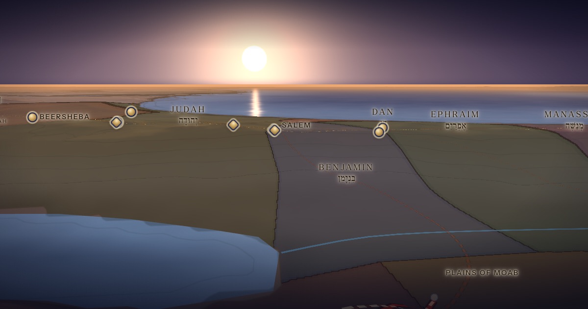
Moses climbs from the plains of Moab to the top of Pisgah. God shows him the whole land — Gilead as far as Dan, Naphtali, Ephraim and Manasseh, Judah to the western sea, the Negev, and the plain of Jericho, the city of palm trees, as far as Zoar. “I have caused thee to see it with thine eyes, but thou shalt not go over thither.” Moses dies there, at 120; no one knows his burial place to this day.
Location
Mount Nebo is traditionally the Siyagha ridge north-west of Madaba, where a Byzantine church commemorates Moses. The biblical description — “over against Jericho” — fits the western edge of the plateau.
- Mount Nebo — Pisgahהַר נְבוֹ — Ras Siyagha, Jordan (tradition)Traditional identification 31.77° N, 35.73° EMoses sees the land from afar.
Related sites
- Khirbet el-MukhayyatScholarly proposalThe town of Nebo (Num. 32:38; Mesha Stele).
The journey
The plains → Mount Nebo≈ 15 km
Roughly 1 day on foot.
Distances are estimates along plausible ancient corridors, not measured routes.
Chronology
Moses dies on 7 Adar 1273 BCE (Hebrew year 2488, by the traditional reckoning), at 120 years. As the ArtScroll Chumash charts it, that day he writes thirteen Torah scrolls — one for each tribe, and one to be kept beside the Ark (Deut. 31:26) — climbs Nebo, sees the land, and dies. The manna stops falling, but Israel eats what it has gathered until after the omer on 16 Nisan (Josh. 5:11–12; Kiddushin 38a). Thirty days of mourning follow (Deut. 34:8), and Israel crosses the Jordan on 10 Nisan (Josh. 4:19).
Parshiyos
- Va’eschananואתחנן · Deuteronomy 3:23
- Ha’azinuהאזינו · Deuteronomy 32:1
- V’zos HaBerachahוזאת הברכה · Deuteronomy 33:1
The weekly readings the atlas places at this chapter.
Biblical Narrative
God tells Moses to ascend and see the land, and then to die, as Aaron died on Mount Hor (32:49–50). Moses dies “according to the word of the LORD” and is buried in the valley in the land of Moab, over against Beth-peor (34:5–6). “His eye was not dim, nor his natural force abated” (34:7). Israel mourns thirty days; Joshua succeeds him (34:8–9).
Geography
From Ras Siyagha, about 700 m above sea level, the ground falls more than 1,100 m to the Dead Sea and the Jordan valley. On clear days one can see Jericho, the Judean hills and the ridge of Jerusalem and Bethlehem; the text’s wider panorama — to Dan and the “hinder sea” — exceeds any physical view, and tradition read it as a vision.
Historical Context
Nebo appears as an Israelite-held town on the Mesha Stele (c. 840 BCE), in which the Moabite king records his god’s command: “Go, take Nebo from Israel.”
Archaeology
Excavations by the Franciscans of the Studium Biblicum Franciscanum (Sylvester Saller from 1933, and later Michele Piccirillo) uncovered a 4th-century memorial church of Moses, enlarged in the 6th century with remarkable mosaics. The pilgrim Egeria was shown the site in the 380s.
Jewish Tradition
“No man knoweth of his sepulchre unto this day” (34:6). The Talmud (Sotah 13b) tells that those who searched for the grave from the summit saw it below, and those below saw it above. Rashi (on Deut. 34:1–3) reads the panorama as a vision of Israel’s future history in each region.
Traditional and rabbinic interpretation — presented as tradition, not as archaeological evidence.
Identification
- What the text says
- “Mount Nebo… in the land of Moab, that is over against Jericho” (32:49); “the top of Pisgah” (34:1).
- Traditional identification
- Ras Siyagha (Byzantine memorial church) and nearby Khirbet el-Mukhayyat, the town of Nebo. The tribal portions shown on the map during the view follow the traditional map in the ArtScroll Chumash, after Joshua 13–19; their boundaries are approximate.
- Scholarly proposals
- The Siyagha–Mukhayyat ridge fits the description; the identification is traditional but reasonable.
- What remains uncertain
- Moses’ burial place is unknown — as the text itself says.
Sources
Hebrew Bible
- Deuteronomy 32:48–52דברים ל״ב:מ״ח–נ״ב
- Deuteronomy 34:1–12דברים ל״ד:א׳–י״ב
Verse numbers follow the Hebrew (Masoretic) text. Links open the text in Hebrew and English on Sefaria.
Jewish tradition & interpretation
Interpretive tradition — not archaeological evidence.
- Babylonian Talmud (Talmud Bavli), redacted c. 6th century CE. — Sotah 13bבבלי סוטה י״ג ב
- Babylonian Talmud (Talmud Bavli), redacted c. 6th century CE. — Kiddushin 38aבבלי קידושין ל״ח א
- Rashi (R. Shlomo Yitzḥaki, 1040–1105), Commentary on the Torah. — on Deut. 34:1–3רש״י על דברים ל״ד:א׳–ג׳
Ancient & late-antique witnesses
- Egeria, Itinerarium (c. 381–384 CE); trans. John Wilkinson, Egeria’s Travels, 3rd ed. (Warminster: Aris & Phillips, 1999).
- Mesha Stele (Moabite Stone, c. 840 BCE), found at Dhiban in 1868; Musée du Louvre, AO 5066.
Modern scholarship
- Michele Piccirillo and Eugenio Alliata (eds.), Mount Nebo: New Archaeological Excavations 1967–1997 (Jerusalem: Studium Biblicum Franciscanum, 1998).
- Jeffrey H. Tigay, The JPS Torah Commentary: Deuteronomy (Philadelphia: Jewish Publication Society, 1996).
Atlases & reference works
- The ArtScroll Chumash, Appendix A: “Charts, Illustrations, and Maps” (Brooklyn: Mesorah Publications, 2015), pp. 1350–1354. — p. 1353 The traditional Jewish basis for the wilderness route drawn here: the order of the stations of Numbers 33, Kadesh as Rithmah, Mount Hor west of the Arabah, and the way east of Moab. Also the source of the chronology of the fortieth year, Sihon’s strip north of the Arnon, and the tribes on Gerizim and Ebal. It marks most stations as uncertain, and its maps are schematic.
Translation
- The Holy Scriptures According to the Masoretic Text (Philadelphia: Jewish Publication Society of America, 1917). Source of the short quotations on each card (public domain). Verse numbers follow the Hebrew text.