
Chapter XLIIExodus & WildernessמדברTransjordan
עבר הירדן
Transjordan
Sihon and Og
Elul 1274 BCE – Teves 1274/73 BCEHebrew years 2487–2488traditionalאלול ב׳תפ״ז – טבת ב׳תפ״ח
קוּמוּ סְּעוּ וְעִבְרוּ אֶת־נַחַל אַרְנֹן
“Rise ye up, take your journey, and pass over the valley of Arnon.”
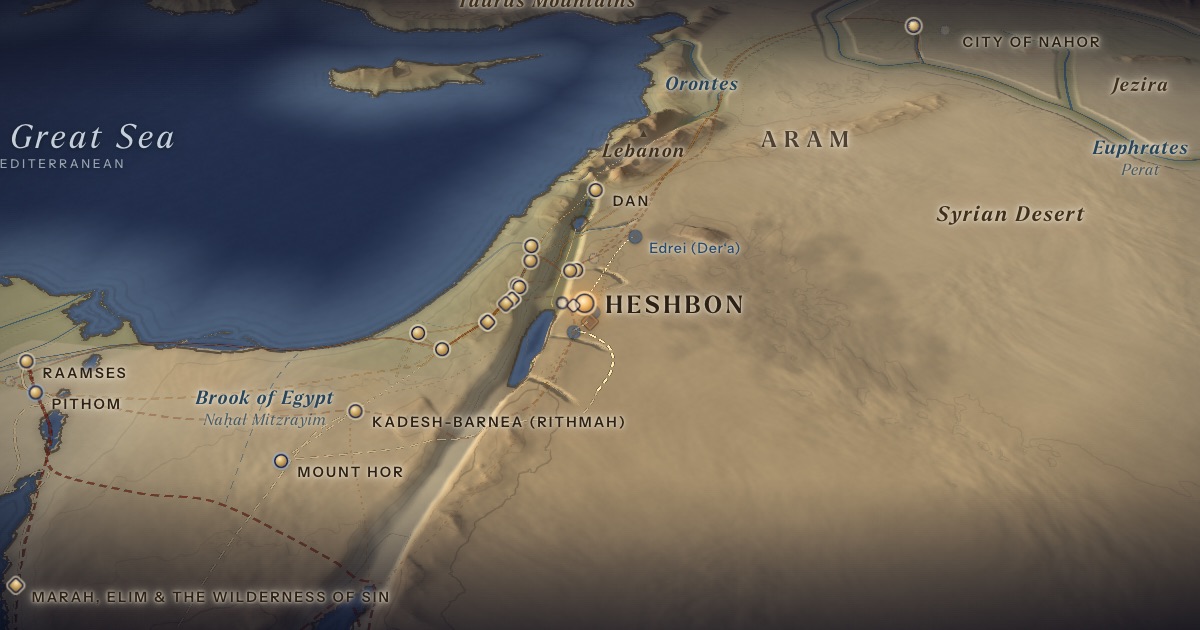
Keeping to the desert east of Moab, which refused them passage, Israel crosses the upper Arnon into the land the Amorite king Sihon had taken from Moab, and camps at Dibon-gad and Almon-diblathaim. Sihon, king of Heshbon, refuses passage and is defeated at Jahaz. In the north, Og, king of Bashan, falls at Edrei. The tribes of Reuben, Gad and half of Manasseh will settle these lands.
Location
As on the ArtScroll Chumash maps, the route runs north through the desert east of Moab and crosses the Arnon into Sihon’s strip, which stretched from the Arnon north past Heshbon. Dibon-gad is probably Dhiban; Almon-diblathaim is unlocated. Heshbon is usually identified with Tell Ḥisbān near Madaba, though excavations found no Late Bronze Age city there; Edrei is Der‘a in southern Syria.
- Heshbonחֶשְׁבּוֹן — Tell Ḥisbān (identification debated)Disputed 31.80° N, 35.81° ECity of Sihon, king of the Amorites.
Proposed locations
- Tell JalulScholarly proposalAlternative candidate for Sihon’s Heshbon.
- Edrei (Der‘a)Scholarly proposalOg’s battlefield (probable).
- Dibon (Dhiban)Scholarly proposalThe station Dibon-gad, station 39 (Num. 33:45); the Mesha Stele was found here in 1868.
- Almon-diblathaim (?)Tradition · ArtScroll Chumash mapStation 40 (Num. 33:46), drawn north-east of Dibon. Position approximate; unlocated.
The journey
Iye-abarim → across the Arnon → Dibon-gad≈ 80 km
“In the wilderness which is in front of Moab, toward the sunrising” (Num. 21:11), crossing the upper Arnon into the strip Sihon had taken from Moab. Roughly 5–8 days at the pace of a people on the move. Route conjectural.
Dibon-gad → Almon-diblathaim≈ 20 km
Roughly 1–2 days at the pace of a people on the move. Route conjectural.
Heshbon → Edrei≈ 100 km
The campaign against Og of Bashan. Roughly 3–4 days on foot. Route conjectural.
Distances are estimates along plausible ancient corridors, not measured routes.
Chronology
Elul to Teves of the fortieth year (1274–1273 BCE), as charted in the ArtScroll Chumash: Israel goes around the border of Moab and crosses the Arnon; the complaint about the manna brings the fiery serpents; Sihon and then Og come out to battle and their lands are taken; and Israel moves on to the plains of Moab.
Biblical Narrative
Israel camps at the brook Zered and beyond the Arnon (21:12–13); Numbers 33 lists the camps as Dibon-gad and Almon-diblathaim (33:45–46). Sihon comes out to Jahaz and is defeated; Israel dwells in the cities of the Amorites (21:21–31). Og comes out to battle at Edrei; his iron bedstead, the text notes, could still be seen in Rabbah of the Ammonites (Deut. 3:11).
Geography
The Zered (Wadi al-Hasa) and the Arnon (Wadi al-Mujib) drop from the plateau to the Dead Sea in gorges hundreds of metres deep. They formed natural borders — the Zered between Edom and Moab, the Arnon “the border of Moab, between Moab and the Amorites” (21:13). Sihon had taken the land north of the Arnon from an earlier king of Moab (21:26), so Israel could camp there without entering Moab. ArtScroll’s map of this verse shades that strip, from the Arnon north past Heshbon to the old border between Moab and the Amorites. North of them lie the tableland (mishor) of Madaba and Heshbon, the hills of Gilead, and the basalt plateau of Bashan.
Historical Context
Numbers 21:27–30 quotes an old victory song over Heshbon, and 21:14 cites a lost “book of the Wars of the LORD” — windows onto earlier poetic sources. The Mesha Stele (c. 840 BCE) shows Israel and Moab contesting this plateau in the 9th century BCE.
Archaeology
Excavations at Tell Ḥisbān (from 1968, by Andrews University) found Iron Age and later remains but nothing from the Late Bronze Age — so either Sihon’s Heshbon lay elsewhere (Tell Jalul has been proposed), or the conquest traditions reflect later realities.
Jewish Tradition
Rabbinic tradition portrays Og as a giant who survived the Flood (Niddah 61a), and identifies him with “the fugitive” who told Abram of Lot’s capture (Rashi on Gen. 14:13).
Traditional and rabbinic interpretation — presented as tradition, not as archaeological evidence.
Identification
- What the text says
- The Zered (21:12); the Arnon, “the border of Moab” (21:13); Heshbon (21:25–26); Jahaz (21:23); Edrei (21:33); Dibon-gad and Almon-diblathaim (33:45–46).
- Traditional identification
- The ArtScroll Chumash map takes Israel north along the desert east of Moab (stations 38–40) and shows wars with Sihon in the land of the Amorite and with Og in Bashan; a second map shows the strip north of the Arnon that Sihon had captured from Moab, where Israel camped.
- Scholarly proposals
- Arnon = Wadi al-Mujib and Zered = Wadi al-Hasa (identified). Heshbon = Tell Ḥisbān (probable, but debated); Edrei = Der‘a (probable); Dibon-gad = Dhiban (probable). Jahaz is uncertain; Almon-diblathaim is often linked with the Beth-diblathaim of Jer. 48:22 and the Mesha Stele.
- What remains uncertain
- The Late Bronze Age horizon of the conquest stories is archaeologically unclear.
Sources
Hebrew Bible
- Numbers 21:10–35במדבר כ״א:י׳–ל״ה
- Numbers 33:44–47במדבר ל״ג:מ״ד–מ״ז
- Deuteronomy 2:9–3:17דברים ב׳:ט׳–ג׳:י״ז
Verse numbers follow the Hebrew (Masoretic) text. Links open the text in Hebrew and English on Sefaria.
Jewish tradition & interpretation
Interpretive tradition — not archaeological evidence.
- Rashi (R. Shlomo Yitzḥaki, 1040–1105), Commentary on the Torah. — on Gen. 14:13רש״י על בראשית י״ד:י״ג
- Babylonian Talmud (Talmud Bavli), redacted c. 6th century CE. — Niddah 61aבבלי נדה ס״א א
Ancient & late-antique witnesses
- Mesha Stele (Moabite Stone, c. 840 BCE), found at Dhiban in 1868; Musée du Louvre, AO 5066.
Modern scholarship
- Jacob Milgrom, The JPS Torah Commentary: Numbers (Philadelphia: Jewish Publication Society, 1990).
- Jeffrey H. Tigay, The JPS Torah Commentary: Deuteronomy (Philadelphia: Jewish Publication Society, 1996).
Atlases & reference works
- Burton MacDonald, “East of the Jordan”: Territories and Sites of the Hebrew Scriptures (Boston: American Schools of Oriental Research, 2000).
- The ArtScroll Chumash, Appendix A: “Charts, Illustrations, and Maps” (Brooklyn: Mesorah Publications, 2015), pp. 1350–1354. — pp. 1350–1351, 1353 The traditional Jewish basis for the wilderness route drawn here: the order of the stations of Numbers 33, Kadesh as Rithmah, Mount Hor west of the Arabah, and the way east of Moab. Also the source of the chronology of the fortieth year, Sihon’s strip north of the Arnon, and the tribes on Gerizim and Ebal. It marks most stations as uncertain, and its maps are schematic.
Translation
- The Holy Scriptures According to the Masoretic Text (Philadelphia: Jewish Publication Society of America, 1917). Source of the short quotations on each card (public domain). Verse numbers follow the Hebrew text.