
Chapter XXXIXExodus & WildernessמדברSinai
מעמד הר סיני
Mount Sinai
The giving of the Torah
6 Sivan · 1313 BCEHebrew year 2448traditionalו׳ סיון ב׳תמ״ח
וְהַר סִינַי עָשַׁן כֻּלּוֹ מִפְּנֵי אֲשֶׁר יָרַד עָלָיו ה׳ בָּאֵשׁ
“Now mount Sinai was altogether on smoke, because the LORD descended upon it in fire.”
In the third month Israel camps before the mountain. Amid thunder, lightning, cloud and the blast of the shofar, God speaks the Ten Commandments. Moses ascends for forty days; the people make a golden calf; the tablets are broken and given again. Israel builds the Tabernacle and stays nearly a year. Where the mountain stands is among the most contested questions in biblical geography.
Location
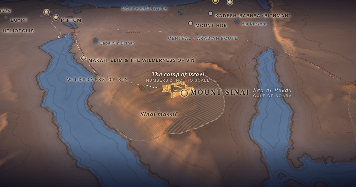
Disputed. The traditional site since the Byzantine era is Jebel Musa (2,285 m) in the southern Sinai massif. Scholars and others have proposed a dozen or more alternatives, from northern Sinai and the Negev to north-western Arabia.
- Mount Sinaiהַר סִינַי — Location disputed — Jebel Musa by traditionDisputed 28.54° N, 33.98° EThe mountain “altogether on smoke.”
Proposed locations
- Jebel MusaTradition · Byzantine tradition, 4th century CE onwardThe traditional Mount Sinai, 2,285 m.
- Jebel SerbalTraditionFavoured by some early monastic communities.
- Gabal Sin BisharScholarly proposal · M. Har-El (1983)West-central Sinai, within reach of Egypt.
- Jebel HelalScholarly proposalNorthern Sinai, near Kadesh-barnea — fits a short route.
- Har KarkomScholarly proposal · E. AnatiNegev plateau with rock art and cult sites of earlier millennia.
- Hala-’l BadrScholarly proposal · A. Musil (1911); C. Humphreys (2003)Volcanic crater in north-western Arabia.
- Jebel al-LawzPopular theoryPromoted in popular media since the 1980s; generally rejected by archaeologists.
The journey
Rephidim → Sinai≈ 40 km
To the traditional Sinai. Roughly 2–4 days at the pace of a people on the move. Route conjectural.
Distances are estimates along plausible ancient corridors, not measured routes.
Chronology
Tradition: the Torah is given on 6 Sivan 1313 BCE (Hebrew year 2448) — the festival of Shavuot.
The date follows the Talmud (Shabbat 86b). Israel leaves Sinai on 20 Iyar of the next year (Num. 10:11).
Parshiyos
- Yisroיתרו · Exodus 18:1
- Mishpatimמשפטים · Exodus 21:1
- Terumahתרומה · Exodus 25:1
- Tetzavehתצוה · Exodus 27:20
- Ki Sisaכי תשא · Exodus 30:11
- Vayakhelויקהל · Exodus 35:1
- Pekudeiפקודי · Exodus 38:21
- Vayikraויקרא · Leviticus 1:1
- Tzavצו · Leviticus 6:1
- Sheminiשמיני · Leviticus 9:1
- Tazriaתזריע · Leviticus 12:1
- Metzoraמצרע · Leviticus 14:1
- Acharei Mosאחרי מות · Leviticus 16:1
- Kedoshimקדשים · Leviticus 19:1
- Emorאמור · Leviticus 21:1
- Beharבהר · Leviticus 25:1
- Bechukosaiבחקתי · Leviticus 26:3
- Bamidbarבמדבר · Numbers 1:1
- Nasoנשא · Numbers 4:21
The weekly readings the atlas places at this chapter.
Biblical Narrative
“In the third month after the children of Israel were gone forth out of the land of Egypt… came they into the wilderness of Sinai” (19:1). The people are kept back from the mountain (19:12). God speaks the Decalogue (20:1–14 [Eng. 20:1–17]). After the golden calf (ch. 32), Moses carves new tablets (ch. 34). The Tabernacle is raised on the first day of the first month of the second year (40:17). Israel departs on the twentieth day of the second month (Num. 10:11).
Geography
The southern Sinai massif is a maze of red and grey granite peaks — Jebel Katherina (2,629 m) is Egypt’s highest — cut by narrow wadis, with springs and a broad plain (er-Raha) below Jebel Musa. Deuteronomy 1:2 gives a rare distance clue: “eleven days’ journey from Horeb unto Kadesh-barnea by the way of mount Seir.” From Jebel Musa to Kadesh is roughly 300–350 km by desert routes — plausible for eleven days at a brisk pace, though several other candidates would also fit.
Historical Context
Christian monks were living around Jebel Musa by the 4th century CE; Egeria visited in the 380s, and Justinian’s monastery followed. No earlier continuous tradition is known; Josephus calls Sinai the highest mountain of the region but gives no location.
Archaeology
No archaeological evidence ties any mountain to the events of Exodus. Emmanuel Anati’s surveys at Har Karkom in the Negev recorded thousands of rock engravings and cult sites — but mainly from the 4th–3rd millennia BCE, far earlier than most proposed Exodus dates.
Jewish Tradition
Jewish tradition cherishes the giving of the Torah — celebrated at Shavuot — far more than the mountain’s location. The Talmud (Sotah 5a) says God chose Sinai, a modest mountain, to teach humility; no site became a Jewish pilgrimage centre in antiquity.
Traditional and rabbinic interpretation — presented as tradition, not as archaeological evidence.
Identification
- What the text says
- Mount Sinai in the wilderness of Sinai (19:1–2), also called Horeb (Deut. 1:6; 4:10); eleven days from Kadesh-barnea by way of Mount Seir (Deut. 1:2).
- Traditional identification
- Jebel Musa (with neighbouring Jebel Katherina and Ras Safsafa) since the 4th century CE; some early monks favoured Jebel Serbal. Traditional Jewish maps, such as the ArtScroll Chumash’s, mark the wilderness of Sinai (station 12) in the southern massif.
- Scholarly proposals
- Other proposals include Gabal Sin Bishar (Har-El), Jebel Helal in northern Sinai, Har Karkom in the Negev (Anati), and peaks in north-western Arabia such as the volcanic Hala-’l Badr (Musil; Humphreys). Jebel al-Lawz in Saudi Arabia is widely promoted in popular media but has little scholarly support.
- What remains uncertain
- The location of Mount Sinai is unknown. The Exodus route on this map leads to Jebel Musa only for orientation.
Sources
Hebrew Bible
- Exodus 19:1–40:38שמות י״ט:א׳–מ׳:ל״ח
- Numbers 1:1–10:10במדבר א׳:א׳–י׳:י׳
- Deuteronomy 5:1–30 (Eng. 5:1–33)דברים ה׳:א׳–ל׳
Verse numbers follow the Hebrew (Masoretic) text. Links open the text in Hebrew and English on Sefaria.
Jewish tradition & interpretation
Interpretive tradition — not archaeological evidence.
- Babylonian Talmud (Talmud Bavli), redacted c. 6th century CE. — Sotah 5aבבלי סוטה ה׳ א
Ancient & late-antique witnesses
- Egeria, Itinerarium (c. 381–384 CE); trans. John Wilkinson, Egeria’s Travels, 3rd ed. (Warminster: Aris & Phillips, 1999).
- Flavius Josephus, Jewish Antiquities (c. 93–94 CE), Loeb Classical Library (Harvard University Press). — 3.76
Modern scholarship
- Emmanuel Anati, The Mountain of God: Har Karkom (New York: Rizzoli, 1986).
- Menashe Har-El, The Sinai Journeys: The Route of the Exodus (San Diego: Ridgefield, 1983).
- Colin J. Humphreys, The Miracles of Exodus (San Francisco: HarperSanFrancisco, 2003).
- James K. Hoffmeier, Ancient Israel in Sinai: The Evidence for the Authenticity of the Wilderness Tradition (New York: Oxford University Press, 2005).
- Graham I. Davies, The Way of the Wilderness: A Geographical Study of the Wilderness Itineraries in the Old Testament (Cambridge: Cambridge University Press, 1979).
- Nahum M. Sarna, The JPS Torah Commentary: Exodus (Philadelphia: Jewish Publication Society, 1991).
Atlases & reference works
- The ArtScroll Chumash, Appendix A: “Charts, Illustrations, and Maps” (Brooklyn: Mesorah Publications, 2015), pp. 1350–1354. — p. 1351 The traditional Jewish basis for the wilderness route drawn here: the order of the stations of Numbers 33, Kadesh as Rithmah, Mount Hor west of the Arabah, and the way east of Moab. Also the source of the chronology of the fortieth year, Sihon’s strip north of the Arnon, and the tribes on Gerizim and Ebal. It marks most stations as uncertain, and its maps are schematic.
Translation
- The Holy Scriptures According to the Masoretic Text (Philadelphia: Jewish Publication Society of America, 1917). Source of the short quotations on each card (public domain). Verse numbers follow the Hebrew text.