
Chapter XXXVIIExodus & WildernessמדברYam Suf
קריעת ים סוף
Yam Suf
The crossing of the sea
21 Nisan · 1313 BCEHebrew year 2448traditionalכ״א ניסן ב׳תמ״ח
שִׁירוּ לַה׳ כִּי־גָאֹה גָּאָה סוּס וְרֹכְבוֹ רָמָה בַיָּם׃
“Sing ye to the LORD, for He is highly exalted: the horse and his rider hath He thrown into the sea.”
God tells Israel to turn back and camp before Pi-hahiroth, between Migdol and the sea, facing Baal-zephon. Pharaoh pursues with chariots. A strong east wind blows all night; Israel walks through the sea on dry ground, and the returning waters cover the Egyptians. Moses and Israel sing; Miriam leads the women with timbrels.
Location
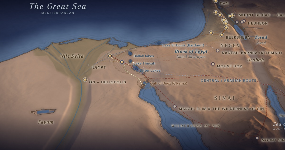
Disputed. The route drawn follows the ArtScroll Chumash map and Tosafot (Arakhin 15a): from Etham Israel turns back to Pi-hahiroth on the western shore of the Gulf of Suez, goes down into the sea, travels north through it in an arc, and comes up at the head of the gulf — on the same side it entered — before going around to Marah on the eastern shore. Where Israel crossed is unknown. “Yam Suf” means “Sea of Reeds,” and scholarly proposals range from the lakes of the Suez isthmus to Lake Sirbonis; the Gulf of Aqaba is a popular theory.
- Yam Sufיַם־סוּף — Crossing point disputedDisputedThe sea divides; Miriam takes up the timbrel.
Proposed locations
- Ballah lakesScholarly proposal · J. K. HoffmeierFormer lakes north of Ismailia, drained by the Suez Canal.
- Lake TimsahScholarly proposalFrontier lake at the eastern end of the Wadi Tumilat.
- Bitter LakesScholarly proposalSalt lakes on the isthmus, perhaps once linked to the Gulf of Suez.
- Pi-hahiroth (traditional)TraditionTraditional maps set the camp on the western shore of the Gulf of Suez, between the mountains (Jebel Ataqa) and the sea. The site itself is unknown.
- Gulf of Suez (Clysma)TraditionThe traditional crossing, at the head of the Gulf of Suez near ancient Clysma (Suez). On the ArtScroll map Israel comes up out of the sea here, at the head of the gulf — the crossing drawn on the map.
- Lake Sirbonis (Bardawil)Scholarly proposal · O. Eissfeldt (1932)Coastal lagoon; Baal-zephon identified with Mount Casius on its sandbar.
- Nuweiba, Gulf of AqabaPopular theoryPopular theory linked to a Midian location for Sinai; generally rejected by scholars.
The journey
Etham → back to Pi-hahiroth≈ 110 km
Turning back toward Egypt (Exod. 14:2), as drawn on traditional maps; Pi-hahiroth is unlocated. Roughly 6–11 days at the pace of a people on the move. Route conjectural.
Through the sea≈ 25 km
Into the sea at Pi-hahiroth and north through it in an arc, coming up at the head of the Gulf of Suez — as on the ArtScroll Chumash map, after Tosafot (Arakhin 15a); where Israel crossed is unknown. Route conjectural.
Distances are estimates along plausible ancient corridors, not measured routes.
Chronology
The seventh day of Passover (Rashi on Exod. 14:5).
Parsha
- Beshalachבשלח · Exodus 13:17
Biblical Narrative
“Speak unto the children of Israel, that they turn back and encamp before Pi-hahiroth” (14:2). Trapped between the sea and the army, the people cry out (14:10–12). The angel and the cloud move behind them (14:19–20). “And the children of Israel went into the midst of the sea upon the dry ground” (14:22). At daybreak the sea returns (14:27–28). The Song of the Sea follows (15:1–18).
Geography
The isthmus of Suez once held a chain of lakes and marshes — the Ballah lakes, Lake Timsah and the Bitter Lakes — along Egypt’s eastern frontier, much altered by the 19th-century Suez Canal. “Suf” elsewhere means reeds (Exod. 2:3), suggesting a reedy lake. Yet in 1 Kings 9:26 “Yam Suf” is the Gulf of Aqaba at Ezion-geber, and in Numbers 33:10 Israel camps “by Yam Suf” after the crossing — apparently the Gulf of Suez. The term may have covered the whole sea system.
Historical Context
In Hebrew, Yam Suf means “Sea of Reeds.” The Greek Septuagint rendered it Erythra Thalassa — the source of a familiar but inexact English name. Migdol (“tower”) was a common name for Egyptian frontier forts; Baal-zephon was a Canaanite storm-god whose cult is attested in Egypt.
Archaeology
No archaeological evidence for the crossing exists. Geological work on the ancient lakes and shorelines of the eastern Delta has clarified the landscape, but it cannot identify an event.
Jewish Tradition
On “that they turn back” (14:2), Rashi explains that on the third day Israel drew back toward Egypt to mislead Pharaoh, so that he would say “they are entangled in the land” (14:3) — the doubling-back drawn on traditional maps. Rashi also identifies Pi-hahiroth with Pithom, renamed for the place where Israel became free (hirut), and the ArtScroll map labels the camp with both names. The Mishnah counts ten miracles at the sea (Avot 5:4); the Midrash describes the sea dividing into twelve paths, one for each tribe (Pirkei de-Rabbi Eliezer 42). Some medieval authorities — notably Tosafot on Arakhin 15a — held that Israel did not cross to the far shore, but went in an arc and came out on the same side; the ArtScroll Chumash map draws the crossing this way, and so does this map.
Traditional and rabbinic interpretation — presented as tradition, not as archaeological evidence.
Identification
- What the text says
- Pi-hahiroth, “between Migdol and the sea, before Baal-zephon” (14:2; Num. 33:7). After the crossing Israel enters the wilderness of Shur (15:22), also called the wilderness of Etham (Num. 33:8).
- Traditional identification
- Traditional Jewish and Christian maps place the crossing at the Gulf of Suez, with Israel camped at Pi-hahiroth on its western shore, hemmed in between the mountains and the sea. Many draw a straight crossing to the eastern shore near ‘Ayun Musa, the “Springs of Moses.” The ArtScroll Chumash map (p. 1351; station 4, “Pi-hahiroth / Pithom”) follows Tosafot (Arakhin 15a) instead: Israel goes into the sea a little south of the head of the gulf, travels north through the water in an arc, and comes up at its head (“Children of Israel ascend from the Sea of Reeds (?)”), then goes around to Marah on the eastern shore. This is the route drawn here.
- Scholarly proposals
- Proposals include the Ballah lakes (favoured by J. K. Hoffmeier), Lake Timsah, the Bitter Lakes, the Gulf of Suez and Lake Sirbonis (O. Eissfeldt, 1932, linking Baal-zephon with Mount Casius). The Gulf of Aqaba (Nuweiba) is popular in non-academic literature but generally rejected by scholars.
- What remains uncertain
- The crossing site is unknown.
Sources
Hebrew Bible
- Exodus 14:1–15:21שמות י״ד:א׳–ט״ו:כ״א
- Numbers 33:7–8במדבר ל״ג:ז׳–ח׳
Verse numbers follow the Hebrew (Masoretic) text. Links open the text in Hebrew and English on Sefaria.
Jewish tradition & interpretation
Interpretive tradition — not archaeological evidence.
- Rashi (R. Shlomo Yitzḥaki, 1040–1105), Commentary on the Torah. — on Exod. 14:2–3רש״י על שמות י״ד:ב׳–ג׳
- Mishnah, tractate Avot (redacted c. 200 CE). — 5:4משנה אבות ה׳:ד׳
- Pirkei de-Rabbi Eliezer, aggadic midrash (c. 8th century CE). — ch. 42פרקי דרבי אליעזר מ״ב
- Tosafot, medieval glosses on the Babylonian Talmud (France and Germany, 12th–13th centuries). — Arakhin 15aתוספות ערכין ט״ו א
Modern scholarship
- Otto Eissfeldt, Baal Zaphon, Zeus Kasios und der Durchzug der Israeliten durchs Meer (Halle: Niemeyer, 1932).
- James K. Hoffmeier, Ancient Israel in Sinai: The Evidence for the Authenticity of the Wilderness Tradition (New York: Oxford University Press, 2005).
- James K. Hoffmeier, Israel in Egypt: The Evidence for the Authenticity of the Exodus Tradition (New York: Oxford University Press, 1997).
- Graham I. Davies, The Way of the Wilderness: A Geographical Study of the Wilderness Itineraries in the Old Testament (Cambridge: Cambridge University Press, 1979).
- Thomas E. Levy, Thomas Schneider and William H. C. Propp (eds.), Israel’s Exodus in Transdisciplinary Perspective (Cham: Springer, 2015).
- Nahum M. Sarna, The JPS Torah Commentary: Exodus (Philadelphia: Jewish Publication Society, 1991).
Atlases & reference works
- The ArtScroll Chumash, Appendix A: “Charts, Illustrations, and Maps” (Brooklyn: Mesorah Publications, 2015), pp. 1350–1354. — p. 1351 The traditional Jewish basis for the wilderness route drawn here: the order of the stations of Numbers 33, Kadesh as Rithmah, Mount Hor west of the Arabah, and the way east of Moab. Also the source of the chronology of the fortieth year, Sihon’s strip north of the Arnon, and the tribes on Gerizim and Ebal. It marks most stations as uncertain, and its maps are schematic.
Translation
- The Holy Scriptures According to the Masoretic Text (Philadelphia: Jewish Publication Society of America, 1917). Source of the short quotations on each card (public domain). Verse numbers follow the Hebrew text.