
Chapter XXXVIIIExodus & WildernessמדברWilderness
מרה · אילם · רפידים
Into the Wilderness
Marah, Elim, manna and Rephidim
1313 BCEHebrew year 2448traditionalב׳תמ״ח
הוּא הַלֶּחֶם אֲשֶׁר נָתַן ה׳ לָכֶם לְאָכְלָה׃
“It is the bread which the LORD hath given you to eat.”
Three days into the wilderness of Shur without water, Israel reaches Marah, whose bitter water Moses sweetens with a tree. At Elim there are twelve springs and seventy palms. In the wilderness of Sin the people hunger; quail come at evening and manna at dawn. At Rephidim Moses strikes the rock for water, and Israel fights Amalek.
Location
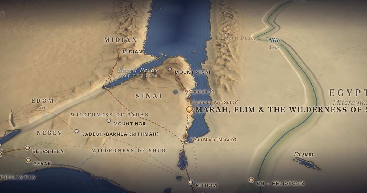
Following the ArtScroll Chumash map, stations 5–10 (Marah, Elim, the camp by Yam Suf, the wilderness of Sin, Dophkah, Alush) run down the eastern shore of the Gulf of Suez before the road turns inland to Rephidim (11). The points use the traditional sites: Marah at ‘Ayun Musa, Elim at Wadi Gharandel, Rephidim at Wadi Feiran. ArtScroll marks almost every station as uncertain, and they all depend on where Sinai is placed.
- Marah, Elim & the Wilderness of Sinמָרָה · אֵילִם · מִדְבַּר־סִין — Western Sinai (traditional)Traditional identification 29.30° N, 32.95° EBitter water made sweet; twelve springs and seventy palms; manna.
Related sites
- ‘Ayun Musa (Marah?)Tradition“Springs of Moses,” a traditional Marah. Station 5.
- Wadi Gharandel (Elim?)TraditionTraditional Elim — palms and springs. Station 6.
- Camp by Yam Suf (?)Tradition · ArtScroll Chumash mapStation 7 (Num. 33:10), on the eastern shore of the Gulf of Suez. Position approximate, as on the map; unlocated.
- Dophkah (?)Tradition · ArtScroll Chumash mapStation 9 (Num. 33:12). Drawn between the wilderness of Sin and Alush; some scholars link the name with the Egyptian turquoise mines (mafkat). Unlocated.
- Alush (?)Tradition · ArtScroll Chumash mapStation 10 (Num. 33:13), the last camp before Rephidim. Position approximate; unlocated.
- Serabit el-KhadimScholarly proposalEgyptian turquoise mines and temple of Hathor; Proto-Sinaitic inscriptions.
- Wadi Feiran (Rephidim?)TraditionThe oasis of Pharan, a traditional Rephidim. Station 11, where Amalek attacks.
The journey
The sea → Marah → Elim → by Yam Suf → Sin≈ 160 km
From the head of the gulf around to Marah, then down the eastern shore of the Gulf of Suez, camping again “by Yam Suf” (Num. 33:10), as on the ArtScroll map; the stations are unlocated. Roughly 9–16 days at the pace of a people on the move. Route conjectural.
Sin → Dophkah → Alush → Rephidim≈ 50 km
Roughly 3–5 days at the pace of a people on the move. Route conjectural.
Distances are estimates along plausible ancient corridors, not measured routes.
Chronology
Marah and Elim in Nisan; the wilderness of Sin on 15 Iyar (Exod. 16:1); then Rephidim.
Biblical Narrative
The people murmur, “What shall we drink?” (15:24). “And they came to Elim, where were twelve springs of water, and threescore and ten palm-trees” (15:27). Manna falls six days a week, with a double portion before the Sabbath (16:4–30). At Massah and Meribah Moses strikes the rock (17:1–7). Joshua fights Amalek while Moses holds up his hands (17:8–16).
Geography
Western Sinai is a coastal plain backed by limestone plateaus and, to the south, the granite massif. Water comes from scattered springs and from wadis that flood briefly after rare storms. A “three days” march without water (15:22) is a lethal distance in this landscape.
Historical Context
Egypt mined turquoise and copper in south-western Sinai for well over a thousand years. At Serabit el-Khadim, near the traditional route, Flinders Petrie found in 1905 the Proto-Sinaitic inscriptions — among the earliest known alphabetic writing, adapted from Egyptian hieroglyphs by Semitic-speaking workers in the 2nd millennium BCE.
Archaeology
No remains attributable to the Israelites have been identified at any wilderness station. Scholars disagree about whether a large group moving through Sinai should be expected to leave traces.
Jewish Tradition
The Talmud (Yoma 75a–b) teaches that the manna tasted differently to the young, the old and infants. When God says Israel “have tried Me these ten times” (Num. 14:22), the Talmud (Arakhin 15a–b) counts them: two at the sea, two over water (Marah and Rephidim), two over the manna, two over the quail, the golden calf, and the spies — a list charted in the ArtScroll Chumash. Early Christian monks identified the oasis of Wadi Feiran — Byzantine Pharan — with Rephidim.
Traditional and rabbinic interpretation — presented as tradition, not as archaeological evidence.
Identification
- What the text says
- Wilderness of Shur (15:22), Marah (15:23), Elim (15:27), Yam Suf (Num. 33:10), wilderness of Sin “between Elim and Sinai” (16:1), Dophkah, Alush (Num. 33:12–13), Rephidim (17:1).
- Traditional identification
- The ArtScroll Chumash map numbers the stations of Numbers 33 and sets 5–10 along the eastern shore of the Gulf of Suez, with Rephidim (11, the war with Amalek) inland, before the wilderness of Sinai (12). Byzantine and later tradition supplies the sites: ‘Ayun Musa (“the Springs of Moses”) for Marah, Wadi Gharandel for Elim, Wadi Feiran for Rephidim.
- Scholarly proposals
- Scholars treat these as traditions only; some connect Dophkah with the Egyptian mining region (Egyptian mafkat, “turquoise”).
- What remains uncertain
- All stations between the sea and Sinai are unlocated.
Sources
Hebrew Bible
- Exodus 15:22–17:16שמות ט״ו:כ״ב–י״ז:ט״ז
- Numbers 33:8–14במדבר ל״ג:ח׳–י״ד
Verse numbers follow the Hebrew (Masoretic) text. Links open the text in Hebrew and English on Sefaria.
Jewish tradition & interpretation
Interpretive tradition — not archaeological evidence.
- Babylonian Talmud (Talmud Bavli), redacted c. 6th century CE. — Yoma 75a–bבבלי יומא ע״ה א–ב
- Babylonian Talmud (Talmud Bavli), redacted c. 6th century CE. — Arakhin 15a–bבבלי ערכין ט״ו א–ב
Modern scholarship
- W. M. Flinders Petrie, Researches in Sinai (London: John Murray, 1906).
- Orly Goldwasser, “How the Alphabet Was Born from Hieroglyphs,” Biblical Archaeology Review 36:2 (2010).
- Graham I. Davies, The Way of the Wilderness: A Geographical Study of the Wilderness Itineraries in the Old Testament (Cambridge: Cambridge University Press, 1979).
- James K. Hoffmeier, Ancient Israel in Sinai: The Evidence for the Authenticity of the Wilderness Tradition (New York: Oxford University Press, 2005).
- Nahum M. Sarna, The JPS Torah Commentary: Exodus (Philadelphia: Jewish Publication Society, 1991).
Atlases & reference works
- The ArtScroll Chumash, Appendix A: “Charts, Illustrations, and Maps” (Brooklyn: Mesorah Publications, 2015), pp. 1350–1354. — pp. 1350–1351 The traditional Jewish basis for the wilderness route drawn here: the order of the stations of Numbers 33, Kadesh as Rithmah, Mount Hor west of the Arabah, and the way east of Moab. Also the source of the chronology of the fortieth year, Sihon’s strip north of the Arnon, and the tribes on Gerizim and Ebal. It marks most stations as uncertain, and its maps are schematic.
Translation
- The Holy Scriptures According to the Masoretic Text (Philadelphia: Jewish Publication Society of America, 1917). Source of the short quotations on each card (public domain). Verse numbers follow the Hebrew text.