
Chapter XXIVPatriarchal AgeאבותJacob
בדרך אפרתה
The Road to Ephrath
Bethel again; Rachel’s tomb
ca. 1556–1554 BCEHebrew years 2205–2207traditionalב׳ר״ה–ב׳ר״ז
וַתָּמָת רָחֵל וַתִּקָּבֵר בְּדֶרֶךְ אֶפְרָתָה הִוא בֵּית לָחֶם׃
“And Rachel died, and was buried in the way to Ephrath—the same is Beth-lehem.”
God sends Jacob back to Bethel, where the name Israel is confirmed. Travelling south, Rachel dies in childbirth “when there was still some way to come to Ephrath,” naming her son Ben-oni; Jacob calls him Benjamin. Jacob sets a pillar on her grave — a site venerated north of Bethlehem to this day, though the Bible itself preserves a second tradition.
Location
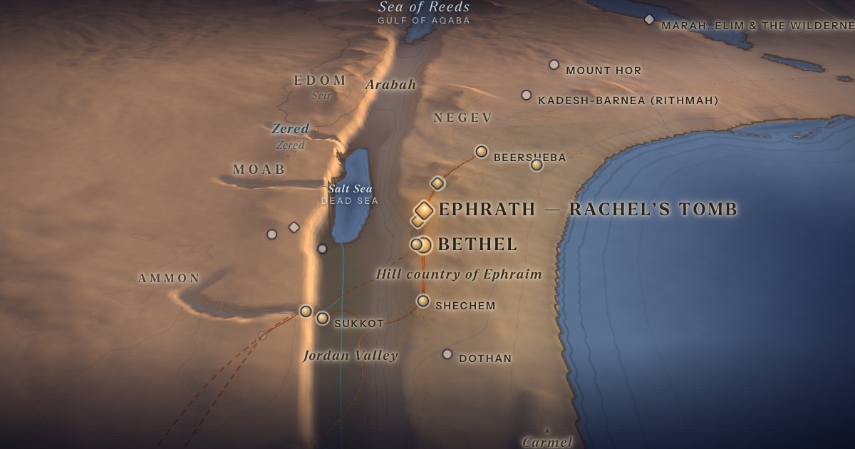
Traditionally Rachel’s Tomb at the northern entrance to Bethlehem. 1 Samuel 10:2 places the tomb “in the border of Benjamin,” which suggests a site north of Jerusalem.
- Ephrath — Rachel’s Tombאֶפְרָתָה — Kever Raḥel, north of Bethlehem (tradition)Traditional identification 31.72° N, 35.20° ERachel dies giving birth to Benjamin “on the way to Ephrath.”
- Bethelבֵּית־אֵל — Beitin (most common identification)Probable identification 31.93° N, 35.24° EAn altar between Bethel and Ai; later, Jacob’s dream.
Related sites
- Near Ramah (north of Jerusalem)Scholarly proposalSuggested by 1 Sam. 10:2 and Jer. 31:14 [Eng. 31:15].
The journey
Shechem → Bethel≈ 35 km
Roughly 2–3 days at the pace of flocks.
Bethel → Ephrath≈ 25 km
Roughly 1–2 days at the pace of flocks.
Distances are estimates along plausible ancient corridors, not measured routes.
Chronology
Within the two years on the road home (Megillah 17a): Bethel, then Rachel’s death on the way to Ephrath.
Biblical Narrative
Jacob’s household buries its foreign gods under the terebinth by Shechem (35:4). At Bethel he builds an altar; Rebekah’s nurse Deborah dies and is buried beneath the “oak of weeping” (35:6–8). God confirms the name Israel (35:10). On the road south, Rachel dies giving birth to Benjamin; Jacob sets a pillar on her grave (35:16–20).
Geography
Bethel to Bethlehem is some 30 km along the ridge. The text measures the remaining distance to Ephrath as kivrat ha-aretz, “a stretch of land” — a unit whose meaning is itself uncertain.
Historical Context
Jeremiah hears “Rachel weeping for her children” in Ramah, north of Jerusalem (Jer. 31:14 [Eng. 31:15]), and Samuel sends Saul past “Rachel’s sepulchre, in the border of Benjamin, at Zelzah” (1 Sam. 10:2). These passages suggest a tradition placing the tomb in Benjamin’s territory rather than near Bethlehem.
Archaeology
The present domed building is largely Ottoman, enlarged by Sir Moses Montefiore in 1841. A monument was already shown here to the Bordeaux Pilgrim in 333 CE.
Jewish Tradition
Rashi (on Gen. 48:7) explains that Jacob buried Rachel by the road so that, when her children were led into exile past her grave, she would weep and plead for them — a tradition drawn from Jeremiah. Rachel’s Tomb near Bethlehem has been a Jewish place of prayer for centuries.
Traditional and rabbinic interpretation — presented as tradition, not as archaeological evidence.
Identification
- What the text says
- “In the way to Ephrath — the same is Beth-lehem” (35:19; 48:7). But 1 Samuel 10:2 places the tomb “in the border of Benjamin.”
- Traditional identification
- Kever Raḥel at the northern entrance to Bethlehem (attested from 333 CE).
- Scholarly proposals
- Many scholars think the gloss “the same is Beth-lehem” reflects a later identification, and that an older tradition placed Ephrath and the tomb north of Jerusalem, near Ramah.
- What remains uncertain
- The original site of the tomb cannot be determined.
Sources
Hebrew Bible
- Genesis 35:1–20בראשית ל״ה:א׳–כ׳
- 1 Samuel 10:2שמואל א י׳:ב׳
- Jeremiah 31:14 (Eng. 31:15)ירמיהו ל״א:י״ד
Verse numbers follow the Hebrew (Masoretic) text. Links open the text in Hebrew and English on Sefaria.
Jewish tradition & interpretation
Interpretive tradition — not archaeological evidence.
- Rashi (R. Shlomo Yitzḥaki, 1040–1105), Commentary on the Torah. — on Gen. 48:7רש״י על בראשית מ״ח:ז׳
Ancient & late-antique witnesses
- Itinerarium Burdigalense (the Bordeaux Pilgrim, 333 CE).
- The Madaba Mosaic Map (6th century CE), Church of St George, Madaba, Jordan; see Michele Piccirillo and Eugenio Alliata (eds.), The Madaba Map Centenary 1897–1997 (Jerusalem: Studium Biblicum Franciscanum, 1999).
Modern scholarship
- Fred Strickert, Rachel Weeping (Collegeville: Liturgical Press, 2007).
- Nahum M. Sarna, The JPS Torah Commentary: Genesis (Philadelphia: Jewish Publication Society, 1989).
Translation
- The Holy Scriptures According to the Masoretic Text (Philadelphia: Jewish Publication Society of America, 1917). Source of the short quotations on each card (public domain). Verse numbers follow the Hebrew text.