
Chapter XLExodus & WildernessמדברKadesh
קדש ברנע
Kadesh-barnea
The spies and the forty years
Av 1312 BCE – Nisan 1274 BCEHebrew years 2449–2487traditionalאב ב׳תמ״ט – ניסן ב׳תפ״ז
בָּאנוּ אֶל־הָאָרֶץ אֲשֶׁר שְׁלַחְתָּנוּ וְגַם זָבַת חָלָב וּדְבַשׁ הִוא וְזֶה־פִּרְיָהּ׃
“We came unto the land whither thou sentest us, and surely it floweth with milk and honey; and this is the fruit of it.”
Leaving Sinai, Israel travels by Taberah, Kibroth-hattaavah and Hazeroth to the wilderness of Paran and Kadesh. Twelve spies scout the land as far as Rehob, cutting a cluster of grapes at Eshcol near Hebron. Ten report giants and fortified cities; the people despair, and are condemned to wander forty years until a new generation grows up.
Location
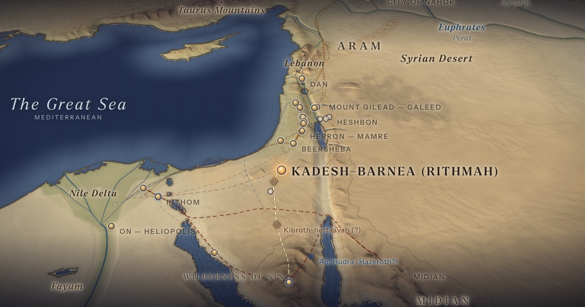
Kadesh-barnea is usually identified with the oasis of ‘Ein el-Qudeirat in north-eastern Sinai — the largest spring in the region — with nearby ‘Ein Qadeis preserving the name. Following Rashi, the ArtScroll Chumash map treats Kadesh as Rithmah, station 15 of Numbers 33, and as station 33, where Israel returns in the fortieth year. Kibroth-hattaavah and Hazeroth are drawn on the way north from Sinai, as on that map; neither is located.
- Kadesh-barnea (Rithmah)קָדֵשׁ בַּרְנֵעַ · רִתְמָה — ʿEin el-Qudeirat (probable)Probable identification 30.65° N, 34.42° ETwelve spies go out; Israel’s longest encampment — stations 15 and 33.
Related sites
- ‘Ein QadeisScholarly proposalA smaller spring that preserves the name Qadesh.
- Kibroth-hattaavah (?)Tradition · ArtScroll Chumash mapStation 13 (Num. 11:34; 33:16), “the graves of craving,” where the quail came. Drawn north of Sinai; position approximate, unlocated.
- Hazeroth (?)Tradition · ArtScroll Chumash mapStation 14 (Num. 11:35; 33:17), where Miriam is shut out of the camp for seven days. Drawn south-west of Kadesh; position approximate, unlocated.
- ‘Ain Hudra (Hazeroth?)Scholarly proposalA spring in eastern Sinai often proposed for Hazeroth, on a route by the Gulf of Aqaba.
The journey
Sinai → Kibroth-hattaavah → Hazeroth → Kadesh≈ 250 km
North across the Sinai plateau to Kadesh (Rithmah), as on the ArtScroll map; Kibroth-hattaavah and Hazeroth are unlocated. Roughly 14–26 days at the pace of a people on the move. Route conjectural.
The spies, as far as Rehob≈ 500 km
North through the hill country to Lebo-hamath. Roughly 14–19 days on foot. Route conjectural.
Distances are estimates along plausible ancient corridors, not measured routes.
Chronology
Tradition: the spies return on 9 Av in the second year after the Exodus (1312 BCE). In the fortieth year (1274 BCE), as charted in the ArtScroll Chumash, Israel reaches the wilderness of Zin and camps at Kadesh on 1 Nisan; Miriam dies on 10 Nisan, and the well that had followed the camp dries up until Moses brings water from the rock at the Waters of Meribah. Israel stays at Kadesh more than three months while Moses asks Edom for passage.
The date of the spies’ return, 9 Av, follows the Talmud (Ta‘anit 29a).
Parshiyos
- Beha’aloschaבהעלתך · Numbers 8:1
- Shelachשלח · Numbers 13:1
- Korachקרח · Numbers 16:1
The weekly readings the atlas places at this chapter.
Biblical Narrative
The spies go up “into the South, and came unto Hebron” (13:22) and bring back grapes, pomegranates and figs (13:23–25). Only Caleb and Joshua urge the people on (14:6–9). An attempt to invade without God’s blessing ends in defeat at Hormah (14:40–45). At Kadesh Miriam dies, and Moses strikes the rock at Meribah (20:1–13).
Geography
Kadesh lies where the Sinai desert meets the Negev highlands, on routes leading north to Beersheba and Hebron and east to the Arabah. Its springs could sustain a long encampment. The spies’ circuit to Rehob near Lebo-hamath and back, “at the end of forty days” (13:25), is on the order of 900–1,000 km.
Historical Context
Much of the wilderness period centres on Kadesh — “ye abode in Kadesh many days” (Deut. 1:46). Numbers 33 lists seventeen stations for the intervening years (33:19–36): Rimmon-perez, Libnah, Rissah, Kehelath, Mount Shepher, Haradah, Makheloth, Tahath, Terah, Mithkah, Hashmonah, Moseroth, Bene-jaakan, Hor-haggidgad, Jotbathah, Abronah and Ezion-geber. Traditional maps such as ArtScroll’s list them as the years of wandering without placing them, and none can be located. Israel then comes back to Kadesh, in the wilderness of Zin (33:36).
Archaeology
Rudolph Cohen’s excavations at Tell el-Qudeirat (1976–1982) uncovered a series of Iron Age fortresses (10th–6th centuries BCE) but no Late Bronze Age remains — the period often proposed for the Exodus. Supporters of the identification note that nomadic encampments leave few traces; critics see the absence as significant.
Jewish Tradition
Kadesh is also called En-mishpat, “the spring of judgement” (Gen. 14:7). Numbers 33 goes from Hazeroth to Rithmah (33:18) with no mention of Kadesh; Rashi explains that Rithmah is Kadesh, named for the spies’ evil report, likened to burning broom (rotem) coals (Ps. 120:3–4). Rabbinic tradition dates the spies’ return to the Ninth of Av — later the day of mourning for both Temples (Mishnah Ta‘anit 4:6; Ta‘anit 29a).
Traditional and rabbinic interpretation — presented as tradition, not as archaeological evidence.
Identification
- What the text says
- Kadesh(-barnea) in the wilderness of Paran (Num. 13:26) and of Zin (20:1), on the border of Edom (20:16), eleven days from Horeb (Deut. 1:2).
- Traditional identification
- Rashi: Kadesh is the Rithmah of Num. 33:18; the ArtScroll Chumash map accordingly labels it “Kadesh-barnea / Rithmah,” stations 15 and 33. Eusebius (Onomasticon) associated Kadesh with the region of Petra.
- Scholarly proposals
- ‘Ein el-Qudeirat (probable); ‘Ein Qadeis preserves the name. Hazeroth has often been sought at ‘Ain Hudra in eastern Sinai, on a route along the Gulf of Aqaba.
- What remains uncertain
- The absence of Late Bronze Age remains is debated; the long encampment may have spread over a wider oasis region.
Sources
Hebrew Bible
- Numbers 10:11–14:45במדבר י׳:י״א–י״ד:מ״ה
- Numbers 20:1–13במדבר כ׳:א׳–י״ג
- Numbers 33:16–37במדבר ל״ג:ט״ז–ל״ז
- Deuteronomy 1:19–46דברים א׳:י״ט–מ״ו
Verse numbers follow the Hebrew (Masoretic) text. Links open the text in Hebrew and English on Sefaria.
Jewish tradition & interpretation
Interpretive tradition — not archaeological evidence.
- Mishnah, redacted by R. Judah ha-Nasi (c. 200 CE). — Ta‘anit 4:6משנה תענית ד׳:ו׳
- Babylonian Talmud (Talmud Bavli), redacted c. 6th century CE. — Ta‘anit 29aבבלי תענית כ״ט א
- Rashi (R. Shlomo Yitzḥaki, 1040–1105), Commentary on the Torah. — on Num. 33:18רש״י על במדבר ל״ג:י״ח
Ancient & late-antique witnesses
- Eusebius of Caesarea, Onomasticon (early 4th century CE); ed. and trans. R. Steven Notley and Ze’ev Safrai (Leiden: Brill, 2005).
Modern scholarship
- Rudolph Cohen and Hannah Bernick-Greenberg, Excavations at Kadesh Barnea (Tell el-Qudeirat) 1976–1982, IAA Reports 34 (Jerusalem: Israel Antiquities Authority, 2007).
- Jacob Milgrom, The JPS Torah Commentary: Numbers (Philadelphia: Jewish Publication Society, 1990).
- Graham I. Davies, The Way of the Wilderness: A Geographical Study of the Wilderness Itineraries in the Old Testament (Cambridge: Cambridge University Press, 1979).
Atlases & reference works
- Ephraim Stern (ed.), The New Encyclopedia of Archaeological Excavations in the Holy Land, 4 vols. (Jerusalem: Israel Exploration Society & Carta, 1993); vol. 5 (2008). — s.v. “Kadesh-Barnea”
- The ArtScroll Chumash, Appendix A: “Charts, Illustrations, and Maps” (Brooklyn: Mesorah Publications, 2015), pp. 1350–1354. — pp. 1351, 1353 The traditional Jewish basis for the wilderness route drawn here: the order of the stations of Numbers 33, Kadesh as Rithmah, Mount Hor west of the Arabah, and the way east of Moab. Also the source of the chronology of the fortieth year, Sihon’s strip north of the Arnon, and the tribes on Gerizim and Ebal. It marks most stations as uncertain, and its maps are schematic.
Translation
- The Holy Scriptures According to the Masoretic Text (Philadelphia: Jewish Publication Society of America, 1917). Source of the short quotations on each card (public domain). Verse numbers follow the Hebrew text.