
Chapter XXXVIExodus & WildernessמדברExodus
יציאת מצרים
Out of Egypt
From Rameses to Succoth
15 Nisan · 1313 BCEHebrew year 2448traditionalט״ו ניסן ב׳תמ״ח
וְלֹא־נָחָם אֱלֹהִים דֶּרֶךְ אֶרֶץ פְּלִשְׁתִּים כִּי קָרוֹב הוּא
“God led them not by the way of the land of the Philistines, although that was near.”
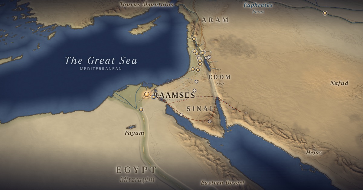
Israel sets out from Rameses to Succoth — about six hundred thousand men on foot, with a mixed multitude, flocks and herds — carrying Joseph’s bones. God leads them not by the short road along the coast, “the way of the land of the Philistines,” but “by the way of the wilderness by Yam Suf,” in a pillar of cloud by day and of fire by night.
Location
Rameses is Pi-Ramesses; Succoth is probably Tjeku, in the Wadi Tumilat. Etham, “in the edge of the wilderness,” is unknown; it is drawn beyond the frontier lakes, where the ArtScroll Chumash map places it.
- Raamsesרַעְמְסֵס — Pi-Ramesses — Qantir / Tell el-DabʿaProbable identification 30.80° N, 31.84° EA store-city built with Israelite labour.
- Succothסֻכֹּת — Tjeku region, Wadi Tumilat (probable)Probable identification 30.55° N, 32.10° EThe first station out of Rameses.
The journey
Rameses → Succoth≈ 40 km
Roughly 2–4 days at the pace of a people on the move.
Succoth → Etham≈ 30 km
Roughly 2–3 days at the pace of a people on the move. Route conjectural.
Distances are estimates along plausible ancient corridors, not measured routes.
Chronology
Traditional date: 15 Nisan 1313 BCE (Hebrew year 2448). Where a historical Exodus is accepted, scholarly proposals cluster around the 15th century BCE (from 1 Kgs 6:1) or the 13th century BCE (a Ramesside setting).
The morning after the first Passover (Num. 33:3).
Parsha
- Boבא · Exodus 10:1
Biblical Narrative
They bake unleavened cakes from the dough they carried out of Egypt (12:39). Moses takes the bones of Joseph (13:19). From Succoth they camp at Etham, “in the edge of the wilderness” (13:20); the pillars of cloud and fire go before them (13:21–22).
Geography
The direct road to Canaan ran along the northern Sinai coast — about 250 km from the Delta to Gaza. The text says God avoided it “lest peradventure the people repent when they see war” (13:17). Egyptian records explain why: New Kingdom pharaohs fortified this road, the “Ways of Horus,” with a chain of forts and wells, shown in a relief of Seti I at Karnak.
Historical Context
The figure of 600,000 men (12:37) implies a population of two million or more — a number that has long challenged historians and commentators. Some scholars reinterpret elef (“thousand”) as a clan or military unit; others regard the numbers as symbolic, or as reflecting later census traditions.
Archaeology
Excavations at Tell el-Borg (James Hoffmeier) and at Tell Hebua, ancient Tjaru (Egyptian teams), have exposed New Kingdom forts on the Ways of Horus. No archaeological trace of the Exodus itself has been found; scholarly views range from a historical core involving a smaller group to a later foundational narrative.
Jewish Tradition
Rashi (on Exod. 12:37) cites a midrash that Rameses to Succoth was 120 mil, covered in an instant. The Passover Haggadah enjoins each generation to see itself as though it had gone out of Egypt.
Traditional and rabbinic interpretation — presented as tradition, not as archaeological evidence.
Identification
- What the text says
- Rameses → Succoth → Etham (12:37; 13:20; Num. 33:5–6).
- Traditional identification
- The ArtScroll Chumash map, followed here, numbers these as the first three stations of Numbers 33: Rameses in the north-eastern Delta, Succoth, and Etham at the edge of the wilderness east of the lakes of the isthmus.
- Scholarly proposals
- Rameses = Pi-Ramesses; Succoth is often equated with Egyptian Tjeku (Wadi Tumilat), perhaps at Tell el-Maskhuta.
- What remains uncertain
- Etham is unknown, and the route beyond Succoth is reconstructed in several ways (see the alternative routes on the map).
Sources
Hebrew Bible
- Exodus 12:37–13:22שמות י״ב:ל״ז–י״ג:כ״ב
- Numbers 33:3–6במדבר ל״ג:ג׳–ו׳
Verse numbers follow the Hebrew (Masoretic) text. Links open the text in Hebrew and English on Sefaria.
Jewish tradition & interpretation
Interpretive tradition — not archaeological evidence.
- Rashi (R. Shlomo Yitzḥaki, 1040–1105), Commentary on the Torah. — on Exod. 12:37רש״י על שמות י״ב:ל״ז
Modern scholarship
- James K. Hoffmeier, Tell el-Borg I (Winona Lake: Eisenbrauns, 2014).
- James K. Hoffmeier, Ancient Israel in Sinai: The Evidence for the Authenticity of the Wilderness Tradition (New York: Oxford University Press, 2005).
- John S. Holladay Jr., Cities of the Delta III: Tell el-Maskhuta (Malibu: Undena, 1982).
- Nahum M. Sarna, The JPS Torah Commentary: Exodus (Philadelphia: Jewish Publication Society, 1991).
- Thomas E. Levy, Thomas Schneider and William H. C. Propp (eds.), Israel’s Exodus in Transdisciplinary Perspective (Cham: Springer, 2015).
- William G. Dever, Who Were the Early Israelites and Where Did They Come From? (Grand Rapids: Eerdmans, 2003).
- Israel Finkelstein and Neil Asher Silberman, The Bible Unearthed: Archaeology’s New Vision of Ancient Israel and the Origin of Its Sacred Texts (New York: Free Press, 2001).
Atlases & reference works
- The ArtScroll Chumash, Appendix A: “Charts, Illustrations, and Maps” (Brooklyn: Mesorah Publications, 2015), pp. 1350–1354. — p. 1351 The traditional Jewish basis for the wilderness route drawn here: the order of the stations of Numbers 33, Kadesh as Rithmah, Mount Hor west of the Arabah, and the way east of Moab. Also the source of the chronology of the fortieth year, Sihon’s strip north of the Arnon, and the tribes on Gerizim and Ebal. It marks most stations as uncertain, and its maps are schematic.
Translation
- The Holy Scriptures According to the Masoretic Text (Philadelphia: Jewish Publication Society of America, 1917). Source of the short quotations on each card (public domain). Verse numbers follow the Hebrew text.