
Chapter XLIIIExodus & WildernessמדברMoab
ערבות מואב
The Plains of Moab
Balaam, and the words of Moses
Elul 1274 BCE – Shevat 1273 BCEHebrew years 2487–2488traditionalאלול ב׳תפ״ז – שבט ב׳תפ״ח
מַה־טֹּבוּ אֹהָלֶיךָ יַעֲקֹב מִשְׁכְּנֹתֶיךָ יִשְׂרָאֵל׃
“How goodly are thy tents, O Jacob, thy dwellings, O Israel!”
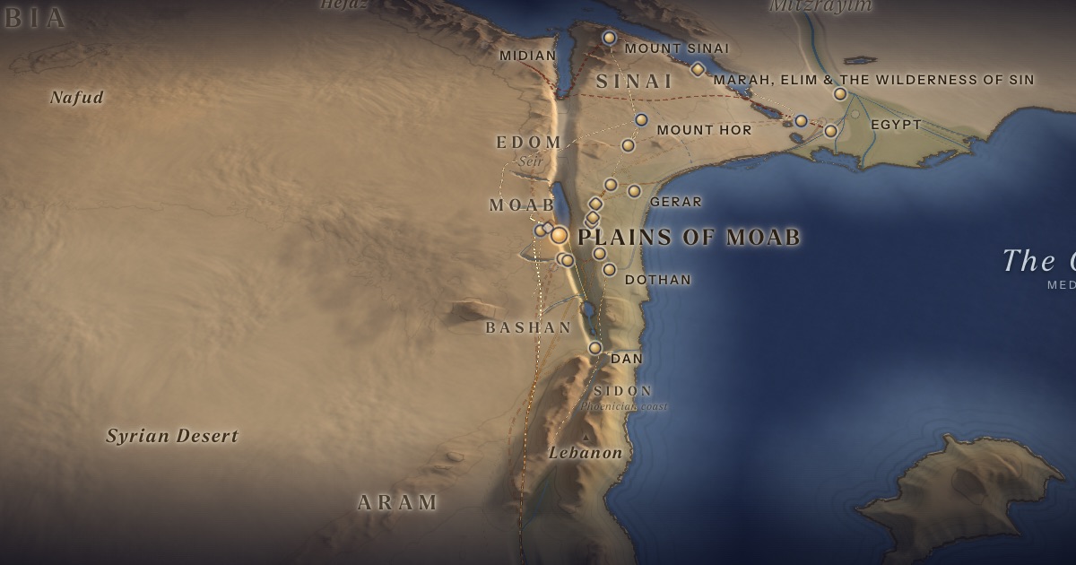
Israel camps in the plains of Moab, across the Jordan from Jericho. Balak, king of Moab, summons the seer Balaam from Pethor on the Euphrates to curse them; three times Balaam blesses instead. Here the second census is taken, the daughters of Zelophehad win their inheritance, and Moses delivers the farewell speeches of Deuteronomy.
Location
The “plains of Moab” are the Jordan valley floor north-east of the Dead Sea, opposite Jericho. Balaam’s home, Pethor, is probably Pitru on the Euphrates, near Carchemish.
- Plains of Moabעַרְבוֹת מוֹאָב — Jordan Valley, north-east of the Dead SeaTextually identified 31.84° N, 35.62° E“Beyond the Jordan at Jericho.”
Related sites
- Pethor (Pitru)Scholarly proposalAssyrian Pitru, south of Carchemish (probable).
- Tell Deir ‘AllaScholarly proposalBalaam inscription (8th century BCE), found 1967.
- Tall el-Hammam (Abel-shittim?)Scholarly proposalOne candidate for Israel’s camp at Abel-shittim.
- Mountains of Abarim (?)Tradition · ArtScroll Chumash mapStation 41 (Num. 33:47), “in front of Nebo” — the western edge of the plateau above the plains. Position approximate.
The journey
Almon-diblathaim → the mountains of Abarim → the plains of Moab≈ 40 km
Roughly 2–4 days at the pace of a people on the move. Route conjectural.
Balaam: Pethor → Moab≈ 650 km
From the Euphrates by the King’s Highway. Roughly 19–27 days on foot. Route conjectural.
Distances are estimates along plausible ancient corridors, not measured routes.
Chronology
The winter of 1274–1273 BCE, as charted in the ArtScroll Chumash: Balak and Balaam, the sin with the daughters of Moab and Midian, Phinehas and the plague, and the war with Midian. On 1 Shevat Moses begins the words of Deuteronomy (Deut. 1:3), explaining the Torah — in seventy languages, says Rashi (on Deut. 1:5). Rashi (on Deut. 4:25) hears in “and ye shall have been long (ve-noshantem) in the land,” whose letters add up to 852, a hint that exile would come after 850 years: entry into the land in 1273 BCE (Hebrew year 2488), the First Temple built in 833 BCE (2928), the Ten Tribes exiled c. 556 BCE (3205), the Temple destroyed in 423 BCE (3338).
Parshiyos
- Balakבלק · Numbers 22:2
- Pinchasפינחס · Numbers 25:10
- Mattosמטות · Numbers 30:2
- Maseiמסעי · Numbers 33:1
- Devarimדברים · Deuteronomy 1:1
- Eikevעקב · Deuteronomy 7:12
- Re’ehראה · Deuteronomy 11:26
- Shoftimשופטים · Deuteronomy 16:18
- Ki Seitzeiכי תצא · Deuteronomy 21:10
- Ki Savoכי תבוא · Deuteronomy 26:1
- Nitzavimנצבים · Deuteronomy 29:9
- Vayeilechוילך · Deuteronomy 31:1
The weekly readings the atlas places at this chapter.
Biblical Narrative
Balak sends for Balaam (22:5–6). Balaam’s donkey sees the angel and speaks (22:22–35). From Bamoth-baal, Pisgah and Peor, Balaam blesses Israel: “How goodly are thy tents, O Jacob” (24:5). Israel sins with the women of Moab and Midian at Baal-peor (ch. 25). Moses expounds the Torah “beyond the Jordan, in the land of Moab” (Deut. 1:5).
Geography
Balaam’s journey from Pethor to Moab is some 650 km — a measure of how far a famous seer’s reputation could travel. The plains are hot and low (roughly 200–350 m below sea level), watered by springs and wadis descending from the plateau, with Jericho’s oasis in view across the river.
Historical Context
In 1967, excavators at Tell Deir ‘Alla in the Jordan valley found an 8th-century BCE plaster inscription describing a night vision of “Balaam son of Beor,” a seer of the gods — the same name and patronym as in Numbers. It does not confirm the biblical episode, but shows that Balaam was a remembered figure in this region.
Archaeology
Tall el-Hammam, the largest Bronze Age site on the plain, has been proposed as Abel-shittim, Israel’s camp here (Num. 33:49) — as well as, separately, as Sodom; Tell Kefrein is another candidate for Abel-shittim.
Jewish Tradition
The Talmud (Berakhot 12b) records that the sages considered including the Balaam passage in the daily Shema. “Mah tovu” (24:5) opens the Jewish morning prayers to this day.
Traditional and rabbinic interpretation — presented as tradition, not as archaeological evidence.
Identification
- What the text says
- From “the mountains of Abarim, in front of Nebo” (33:47) to “the plains of Moab beyond the Jordan at Jericho” (22:1), “from Beth-jeshimoth even unto Abel-shittim” (33:49); Pethor “by the River” (22:5), in Aram-naharaim (Deut. 23:5 [Eng. 23:4]).
- Traditional identification
- The ArtScroll Chumash map ends the journey with the mountains of Abarim (station 41) on the heights north-east of the Salt Sea and the plains of Moab (42) below them, beside the Jordan.
- Scholarly proposals
- The plains are clearly identified. Pethor = Assyrian Pitru, on the Sajur near its junction with the Euphrates (probable).
- What remains uncertain
- Abel-shittim and Beth-jeshimoth are uncertain; the heights where Balaam stood cannot be pinned down.
Sources
Hebrew Bible
- Numbers 22:1–36:13במדבר כ״ב:א׳–ל״ו:י״ג
- Deuteronomy 1:1–5דברים א׳:א׳–ה׳
Verse numbers follow the Hebrew (Masoretic) text. Links open the text in Hebrew and English on Sefaria.
Jewish tradition & interpretation
Interpretive tradition — not archaeological evidence.
- Babylonian Talmud (Talmud Bavli), redacted c. 6th century CE. — Berakhot 12bבבלי ברכות י״ב ב
- Rashi (R. Shlomo Yitzḥaki, 1040–1105), Commentary on the Torah. — on Deut. 1:5; 4:25רש״י על דברים א׳:ה׳; ד׳:כ״ה
Ancient & late-antique witnesses
- J. Hoftijzer and G. van der Kooij, Aramaic Texts from Deir ʿAlla (Leiden: Brill, 1976) — plaster inscription naming “Balaam son of Beor”.
Modern scholarship
- H. J. Franken, Excavations at Tell Deir ʿAllā I (Leiden: Brill, 1969).
- Jacob Milgrom, The JPS Torah Commentary: Numbers (Philadelphia: Jewish Publication Society, 1990).
- Jeffrey H. Tigay, The JPS Torah Commentary: Deuteronomy (Philadelphia: Jewish Publication Society, 1996).
Atlases & reference works
- Burton MacDonald, “East of the Jordan”: Territories and Sites of the Hebrew Scriptures (Boston: American Schools of Oriental Research, 2000).
- The ArtScroll Chumash, Appendix A: “Charts, Illustrations, and Maps” (Brooklyn: Mesorah Publications, 2015), pp. 1350–1354. — pp. 1351, 1353–1354 The traditional Jewish basis for the wilderness route drawn here: the order of the stations of Numbers 33, Kadesh as Rithmah, Mount Hor west of the Arabah, and the way east of Moab. Also the source of the chronology of the fortieth year, Sihon’s strip north of the Arnon, and the tribes on Gerizim and Ebal. It marks most stations as uncertain, and its maps are schematic.
Translation
- The Holy Scriptures According to the Masoretic Text (Philadelphia: Jewish Publication Society of America, 1917). Source of the short quotations on each card (public domain). Verse numbers follow the Hebrew text.